
I've found some USGS imagery that I previously didn't realise was downloadable showing the Swanley Interchange as it looked in 1976. You can make out the isolated bridge on it:Brenley Corner wrote: ↑Fri Jan 12, 2024 14:57I lived in the area at the time but was only about 10 or 11 when the interchange initially opened. I'm guessing that work would have started in around 1974 or 1975 as the M25 to Dartford and the M20 to West Kingsdown opened in 1977 together with the initial layout of Swanley Interchange.RJDG14 wrote: ↑Fri Jan 12, 2024 14:40
Ah, okay. The high resolution 1973 USGS imagery that I downloaded to my hard disk last year shows nothing there aside from the pre-motorway D2 junction (which is still semi-intact), so I'm guessing work hadn't yet started on this junction at the time.
Are there any photos online that show the isolated bridge as it looked a handful of years later?
I have done some searching online but can't unearth any pictures. The bridge did become a minor 'celebrity' in the area at the time as it was so magnificently isolated at the highest level of a huge (for 1977) interchange roundabout for so long, so there must be pictures around but I cannot find them. I also understand that it was featured as an item of interest in a topical magazine TV programme with a song specially composed and performed from the bridge - again there is no easy trace online.
Motorway junctions or bridges that were built prior to their road
Moderator: Site Management Team
Re: Motorway junctions or bridges that were built prior to their road
My guess would be that the bridge remained in this state for some time after the roundabout properly opened. Judging by the "Date Taken" metadata of the original image, the USGS digitised this image at a high resolution in August last year, which was after my initial bulk download in July of available historic imagery of the UK on the EarthExplorer tool, hence why I initially missed this image.
RJDG14
See my Geograph profile here - http://www.geograph.org.uk/profile/74193
The Swindon Files - Swindon's modern history - http://rjdg14.altervista.org/swindon/
----
If I break a policy designed only to protect me and nobody else, have I really broken anything?
See my Geograph profile here - http://www.geograph.org.uk/profile/74193
The Swindon Files - Swindon's modern history - http://rjdg14.altervista.org/swindon/
----
If I break a policy designed only to protect me and nobody else, have I really broken anything?
-
SouthWest Philip

- Member
- Posts: 3483
- Joined: Sun Mar 31, 2002 19:35
- Location: Evesham, Worcestershire
Re: Motorway junctions or bridges that were built prior to their road
Did the direct links north/east-facing between the M25 and M20 open at the same time [1977] as the motorways, or did they come later? I can see in the photo above that the M20 westbound off-slip was built with the length to accommodate the free flow link from the start but there is no sign of it being built simultaneously.
Re: Motorway junctions or bridges that were built prior to their road
Opened quite some time later. At a guess I would say 1990s, as part of the Channel Tunnel/M20 road enhancements. I seem to recall the similar direct links, in the same direction, between the A2 and the Dartford Tunnel came later again.SouthWest Philip wrote: ↑Sun Jan 21, 2024 08:07 Did the direct links north/east-facing between the M25 and M20 open at the same time [1977] as the motorways, or did they come later? I can see in the photo above that the M20 westbound off-slip was built with the length to accommodate the free flow link from the start but there is no sign of it being built simultaneously.

Re: Motorway junctions or bridges that were built prior to their road
You can see the original GSJ remains to the west of the roundabout too in this image. The A20 went from D3 to S2 almost immediately afterwards in that classic Greater London style.RJDG14 wrote: ↑Sat Jan 20, 2024 22:53I've found some USGS imagery that I previously didn't realise was downloadable showing the Swanley Interchange as it looked in 1976. You can make out the isolated bridge on it:Brenley Corner wrote: ↑Fri Jan 12, 2024 14:57I lived in the area at the time but was only about 10 or 11 when the interchange initially opened. I'm guessing that work would have started in around 1974 or 1975 as the M25 to Dartford and the M20 to West Kingsdown opened in 1977 together with the initial layout of Swanley Interchange.RJDG14 wrote: ↑Fri Jan 12, 2024 14:40
Ah, okay. The high resolution 1973 USGS imagery that I downloaded to my hard disk last year shows nothing there aside from the pre-motorway D2 junction (which is still semi-intact), so I'm guessing work hadn't yet started on this junction at the time.
Are there any photos online that show the isolated bridge as it looked a handful of years later?
I have done some searching online but can't unearth any pictures. The bridge did become a minor 'celebrity' in the area at the time as it was so magnificently isolated at the highest level of a huge (for 1977) interchange roundabout for so long, so there must be pictures around but I cannot find them. I also understand that it was featured as an item of interest in a topical magazine TV programme with a song specially composed and performed from the bridge - again there is no easy trace online.
SwanleyInterchange1976.jpg
My guess would be that the bridge remained in this state for some time after the roundabout properly opened. Judging by the "Date Taken" metadata of the original image, the USGS digitised this image at a high resolution in August last year, which was after my initial bulk download in July of available historic imagery of the UK on the EarthExplorer tool, hence why I initially missed this image.
Bryn
Terminally cynical, unimpressed, and nearly Middle Age already.
She said life was like a motorway; dull, grey, and long.
Blog - https://showmeasign.online/
X - https://twitter.com/ShowMeASignBryn
YouTube - https://www.youtube.com/@BrynBuck
Terminally cynical, unimpressed, and nearly Middle Age already.
She said life was like a motorway; dull, grey, and long.
Blog - https://showmeasign.online/
X - https://twitter.com/ShowMeASignBryn
YouTube - https://www.youtube.com/@BrynBuck

Re: Motorway junctions or bridges that were built prior to their road
What a brilliant picture! Thank you for posting.
You can see a temporary roundabout layout during construction of the junction, and you can also see the remnants of the original parclo on that site which are being ripped up. It would only have been ten years old at that point. The A20 west of the junction has been temporarily reduced from D3 to S2 in order to fit onto the future westbound on-slip, but doesn't seem to be suffering in terms of traffic levels.
Chris
Roads.org.uk
Roads.org.uk

Re: Motorway junctions or bridges that were built prior to their road
I agree they (the M20 / M25 direct slips) were definitely several years later, however my vague recollection is late 1980s and I have a 1990 (so published in 1989) Collins road atlas which shows them.WHBM wrote: ↑Sun Jan 21, 2024 11:02Opened quite some time later. At a guess I would say 1990s, as part of the Channel Tunnel/M20 road enhancements. I seem to recall the similar direct links, in the same direction, between the A2 and the Dartford Tunnel came later again.SouthWest Philip wrote: ↑Sun Jan 21, 2024 08:07 Did the direct links north/east-facing between the M25 and M20 open at the same time [1977] as the motorways, or did they come later? I can see in the photo above that the M20 westbound off-slip was built with the length to accommodate the free flow link from the start but there is no sign of it being built simultaneously.
Owen
Re: Motorway junctions or bridges that were built prior to their road
I do seem to recollect passing them on the M25, coned off, for a considerable time after apparent completion but before opening. The Channel Tunnel opened in 1994 so were doubtless part of the additional traffic expected then. They were a considerable benefit westbound. Going from the M20 up the exit ramp and round the signalled roundabout was sometimes taking 10-15 minutes.owen b wrote: ↑Sun Jan 21, 2024 17:15I agree they (the M20 / M25 direct slips) were definitely several years later, however my vague recollection is late 1980s and I have a 1990 (so published in 1989) Collins road atlas which shows them.WHBM wrote: ↑Sun Jan 21, 2024 11:02Opened quite some time later. At a guess I would say 1990s, as part of the Channel Tunnel/M20 road enhancements. I seem to recall the similar direct links, in the same direction, between the A2 and the Dartford Tunnel came later again.SouthWest Philip wrote: ↑Sun Jan 21, 2024 08:07 Did the direct links north/east-facing between the M25 and M20 open at the same time [1977] as the motorways, or did they come later? I can see in the photo above that the M20 westbound off-slip was built with the length to accommodate the free flow link from the start but there is no sign of it being built simultaneously.
Re: Motorway junctions or bridges that were built prior to their road
Looking at SABRE's very own wiki : https://www.sabre-roads.org.uk/wiki/ind ... nterchange it states "In the early 1980s direct slip roads from M20 (London-bound) to M25 (anti-clockwise) and vice-versa were added." The mystery deepensWHBM wrote: ↑Sun Jan 21, 2024 17:34I do seem to recollect passing them on the M25, coned off, for a considerable time after apparent completion but before opening. The Channel Tunnel opened in 1994 so were doubtless part of the additional traffic expected then. They were a considerable benefit westbound. Going from the M20 up the exit ramp and round the signalled roundabout was sometimes taking 10-15 minutes.
Owen
From the SABRE Wiki: Swanley Interchange :
Swanley Interchange is junction 1 of the M20 and junction 3 of the M25.
It was built in 1976/77 concurrently with the M20 to West Kingsdown and the M25 to Dartford to replace a 1966 trumpet junction built for the A20 Swanley Bypass that previously stood on the site. The original 1977 construction provided a high-level bridge over the M20 in readiness for extension of the M25/Ringway 3 westwards but without any embankments or bridges over the roundabout so was
Re: Motorway junctions or bridges that were built prior to their road
The USGS EarthExplorer tool is probably one of the most valuable tools for finding aerial imagery of the UK taken between the 1950s and 1980s (despite it only having a small proportion of its images of the UK currently digitised at a high resolution; nearly all high resolution imagery of countries outside the US is under the "Declass 1/2/3" categories). Because they were taken by a US government authority and made available on a US government site, the images are also in the public domain as per US law, much like the old 1940s Air Force imagery where the copyright expired 25-30 years ago (unlike the 50 year rule for the UK, US government imagery is out of copyright from the point it is published), which makes such imagery safe to share and use elsewhere (although they do request that you give the USGS credit, much like how the Ordnance Survey requests you give credit when using scans of over 50 year old maps).Chris5156 wrote: ↑Sun Jan 21, 2024 17:10What a brilliant picture! Thank you for posting.
You can see a temporary roundabout layout during construction of the junction, and you can also see the remnants of the original parclo on that site which are being ripped up. It would only have been ten years old at that point. The A20 west of the junction has been temporarily reduced from D3 to S2 in order to fit onto the future westbound on-slip, but doesn't seem to be suffering in terms of traffic levels.
In case you haven't already seen it, both me and Johnathan404 have uploaded highlights of the currently available USGS imagery (mostly historic junction layouts from the 1970s) to a gallery on the wiki:
https://www.sabre-roads.org.uk/wiki/ind ... ic_Imagery
RJDG14
See my Geograph profile here - http://www.geograph.org.uk/profile/74193
The Swindon Files - Swindon's modern history - http://rjdg14.altervista.org/swindon/
----
If I break a policy designed only to protect me and nobody else, have I really broken anything?
See my Geograph profile here - http://www.geograph.org.uk/profile/74193
The Swindon Files - Swindon's modern history - http://rjdg14.altervista.org/swindon/
----
If I break a policy designed only to protect me and nobody else, have I really broken anything?
Re: Motorway junctions or bridges that were built prior to their road
While 1980s OS maps can't be uploaded to SABRE until the 2030s, does anyone on the site have a 1980s OS map covering the interchange, and if so, does it show them or not?owen b wrote: ↑Sun Jan 21, 2024 17:52Looking at SABRE's very own wiki : https://www.sabre-roads.org.uk/wiki/ind ... nterchange it states "In the early 1980s direct slip roads from M20 (London-bound) to M25 (anti-clockwise) and vice-versa were added." The mystery deepensWHBM wrote: ↑Sun Jan 21, 2024 17:34I do seem to recollect passing them on the M25, coned off, for a considerable time after apparent completion but before opening. The Channel Tunnel opened in 1994 so were doubtless part of the additional traffic expected then. They were a considerable benefit westbound. Going from the M20 up the exit ramp and round the signalled roundabout was sometimes taking 10-15 minutes..
RJDG14
See my Geograph profile here - http://www.geograph.org.uk/profile/74193
The Swindon Files - Swindon's modern history - http://rjdg14.altervista.org/swindon/
----
If I break a policy designed only to protect me and nobody else, have I really broken anything?
See my Geograph profile here - http://www.geograph.org.uk/profile/74193
The Swindon Files - Swindon's modern history - http://rjdg14.altervista.org/swindon/
----
If I break a policy designed only to protect me and nobody else, have I really broken anything?
From the SABRE Wiki: Swanley Interchange :
Swanley Interchange is junction 1 of the M20 and junction 3 of the M25.
It was built in 1976/77 concurrently with the M20 to West Kingsdown and the M25 to Dartford to replace a 1966 trumpet junction built for the A20 Swanley Bypass that previously stood on the site. The original 1977 construction provided a high-level bridge over the M20 in readiness for extension of the M25/Ringway 3 westwards but without any embankments or bridges over the roundabout so was
Re: Motorway junctions or bridges that were built prior to their road
I've got at least one copy of all the OS 1:50,000 maps. Unfortunately my copy of Sheet 177 East London is "Major roads revised 1977" so it has M25 J2-3, M20 J1 to the temporary terminus south east of West Kingsdown, and without the direct slips at the junction.RJDG14 wrote: ↑Sun Jan 21, 2024 18:30While 1980s OS maps can't be uploaded to SABRE until the 2030s, does anyone on the site have a 1980s OS map covering the interchange, and if so, does it show them or not?owen b wrote: ↑Sun Jan 21, 2024 17:52Looking at SABRE's very own wiki : https://www.sabre-roads.org.uk/wiki/ind ... nterchange it states "In the early 1980s direct slip roads from M20 (London-bound) to M25 (anti-clockwise) and vice-versa were added." The mystery deepensWHBM wrote: ↑Sun Jan 21, 2024 17:34
I do seem to recollect passing them on the M25, coned off, for a considerable time after apparent completion but before opening. The Channel Tunnel opened in 1994 so were doubtless part of the additional traffic expected then. They were a considerable benefit westbound. Going from the M20 up the exit ramp and round the signalled roundabout was sometimes taking 10-15 minutes.
Owen
From the SABRE Wiki: Swanley Interchange :
Swanley Interchange is junction 1 of the M20 and junction 3 of the M25.
It was built in 1976/77 concurrently with the M20 to West Kingsdown and the M25 to Dartford to replace a 1966 trumpet junction built for the A20 Swanley Bypass that previously stood on the site. The original 1977 construction provided a high-level bridge over the M20 in readiness for extension of the M25/Ringway 3 westwards but without any embankments or bridges over the roundabout so was
-
RichardA35

- Elected Committee Member
- Posts: 5723
- Joined: Thu Jul 11, 2002 18:58
- Location: Dorset
Re: Motorway junctions or bridges that were built prior to their road
A look at Promap (which has a similar to "old-maps.co.uk" preview facility):owen b wrote: ↑Sun Jan 21, 2024 17:52 Looking at SABRE's very own wiki : https://www.sabre-roads.org.uk/wiki/ind ... nterchange it states "In the early 1980s direct slip roads from M20 (London-bound) to M25 (anti-clockwise) and vice-versa were added." The mystery deepens
the 1982 1:10,000 plan is a representation of the final layout after the satellite photograph with the M25 bridge built but unconnected;
the 1989 1:10,000 plan shows the M25 bridge in use and the direct M20-M25 slip roads open
From the SABRE Wiki: Swanley Interchange :
Swanley Interchange is junction 1 of the M20 and junction 3 of the M25.
It was built in 1976/77 concurrently with the M20 to West Kingsdown and the M25 to Dartford to replace a 1966 trumpet junction built for the A20 Swanley Bypass that previously stood on the site. The original 1977 construction provided a high-level bridge over the M20 in readiness for extension of the M25/Ringway 3 westwards but without any embankments or bridges over the roundabout so was
Re: Motorway junctions or bridges that were built prior to their road
This would suggest that they might have been built with the M25 extension/joinup. I think the M25 was completed in about 1986/87.RichardA35 wrote: ↑Sun Jan 21, 2024 20:29A look at Promap (which has a similar to "old-maps.co.uk" preview facility):owen b wrote: ↑Sun Jan 21, 2024 17:52 Looking at SABRE's very own wiki : https://www.sabre-roads.org.uk/wiki/ind ... nterchange it states "In the early 1980s direct slip roads from M20 (London-bound) to M25 (anti-clockwise) and vice-versa were added." The mystery deepens
the 1982 1:10,000 plan is a representation of the final layout after the satellite photograph with the M25 bridge built but unconnected;
the 1989 1:10,000 plan shows the M25 bridge in use and the direct M20-M25 slip roads open
The fact that the main M25 bridge at Swanley was originally built without embankments or bridges over the roundabout does seem a little weird in my opinion. In most cases embankments would have been built with any bridges if the roundabout was grade separated from the start; for example, here's the junction to the north in 1973:
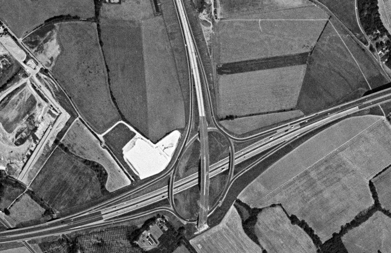
Swanley doesn't seem to have been built that way. The 1976 USGS imagery shows the junction above with the road immediately to the south under construction.
RJDG14
See my Geograph profile here - http://www.geograph.org.uk/profile/74193
The Swindon Files - Swindon's modern history - http://rjdg14.altervista.org/swindon/
----
If I break a policy designed only to protect me and nobody else, have I really broken anything?
See my Geograph profile here - http://www.geograph.org.uk/profile/74193
The Swindon Files - Swindon's modern history - http://rjdg14.altervista.org/swindon/
----
If I break a policy designed only to protect me and nobody else, have I really broken anything?
From the SABRE Wiki: Swanley Interchange :
Swanley Interchange is junction 1 of the M20 and junction 3 of the M25.
It was built in 1976/77 concurrently with the M20 to West Kingsdown and the M25 to Dartford to replace a 1966 trumpet junction built for the A20 Swanley Bypass that previously stood on the site. The original 1977 construction provided a high-level bridge over the M20 in readiness for extension of the M25/Ringway 3 westwards but without any embankments or bridges over the roundabout so was
Re: Motorway junctions or bridges that were built prior to their road
The 1984 1:50000 Edition B/*/*/* Selected Revision 1984 shows the direct link from M20 to M25.RJDG14 wrote: ↑Sun Jan 21, 2024 18:30While 1980s OS maps can't be uploaded to SABRE until the 2030s, does anyone on the site have a 1980s OS map covering the interchange, and if so, does it show them or not?owen b wrote: ↑Sun Jan 21, 2024 17:52Looking at SABRE's very own wiki : https://www.sabre-roads.org.uk/wiki/ind ... nterchange it states "In the early 1980s direct slip roads from M20 (London-bound) to M25 (anti-clockwise) and vice-versa were added." The mystery deepensWHBM wrote: ↑Sun Jan 21, 2024 17:34
I do seem to recollect passing them on the M25, coned off, for a considerable time after apparent completion but before opening. The Channel Tunnel opened in 1994 so were doubtless part of the additional traffic expected then. They were a considerable benefit westbound. Going from the M20 up the exit ramp and round the signalled roundabout was sometimes taking 10-15 minutes.
Just to add intrigue - the larger scale London maps of the Philips Road Atlas of 1977 shows the roundabout interchange but the 1978 edition has the direct link from M25 to M20 on.
I've had no joy trying to glean the information from the Gazette notices.
Ian
From the SABRE Wiki: Swanley Interchange :
Swanley Interchange is junction 1 of the M20 and junction 3 of the M25.
It was built in 1976/77 concurrently with the M20 to West Kingsdown and the M25 to Dartford to replace a 1966 trumpet junction built for the A20 Swanley Bypass that previously stood on the site. The original 1977 construction provided a high-level bridge over the M20 in readiness for extension of the M25/Ringway 3 westwards but without any embankments or bridges over the roundabout so was
-
RichardA35
- Elected Committee Member
- Posts: 5723
- Joined: Thu Jul 11, 2002 18:58
- Location: Dorset
Re: Motorway junctions or bridges that were built prior to their road
Another view from 1957 hereRJDG14 wrote: ↑Tue Jan 16, 2024 22:04 In the case of the Maidenhead bypass, the section that had been semi constructed just before the start of WWII (which lay abandoned for about 20 years) went from the original western terminus roundabout (which also clearly looked half built) with the A4 to just east of the Thames bridge on the modern M4. It looks like two bridges were semi constructed as part of the original 1930s project, one over the Great Western Railway (which was the most complete and featured several deck support beams over the railway, but no proper road deck) and one over the Thames (which had the support columns in place but no deck support beams or road deck). I suspect the lack of other bridges was down to design standards of the day - most of the roads that crossed the route of it would have probably had an at-grade intersection, similar to on the original Winchester Bypass.
-
RichardA35
- Elected Committee Member
- Posts: 5723
- Joined: Thu Jul 11, 2002 18:58
- Location: Dorset
Re: Motorway junctions or bridges that were built prior to their road
...and here's a picture of Mar Dyke after it opened, before the A13 was extended west.RichardA35 wrote: ↑Fri Jan 12, 2024 10:36That's the southern of the pair of roundabouts - Mardyke is the northern one of the pair where the A13 now crosses and where the flyover was built ahead of the westwards extension of the improved A13.RJDG14 wrote: ↑Thu Jan 11, 2024 22:58Here's what the northern end of the Dartford Tunnel approach at Mardyke looked like at the same time:Patrick Harper wrote: ↑Thu Jan 11, 2024 20:38 The top-level flyovers at Swanley and Mardyke are classic examples.
It was originally built without flyovers.
-
RichardA35
- Elected Committee Member
- Posts: 5723
- Joined: Thu Jul 11, 2002 18:58
- Location: Dorset
Re: Motorway junctions or bridges that were built prior to their road
I've narrowed down the order to SI 1973/1607 The Mid Kent Motorway M20 (Swanley—Farningham Section) Connecting Roads (No. 2) Scheme 1973Ross Spur wrote: ↑Sun Jan 21, 2024 22:31The 1984 1:50000 Edition B/*/*/* Selected Revision 1984 shows the direct link from M20 to M25.RJDG14 wrote: ↑Sun Jan 21, 2024 18:30While 1980s OS maps can't be uploaded to SABRE until the 2030s, does anyone on the site have a 1980s OS map covering the interchange, and if so, does it show them or not?owen b wrote: ↑Sun Jan 21, 2024 17:52
Looking at SABRE's very own wiki : https://www.sabre-roads.org.uk/wiki/ind ... nterchange it states "In the early 1980s direct slip roads from M20 (London-bound) to M25 (anti-clockwise) and vice-versa were added." The mystery deepens
Just to add intrigue - the larger scale London maps of the Philips Road Atlas of 1977 shows the roundabout interchange but the 1978 edition has the direct link from M25 to M20 on.
I've had no joy trying to glean the information from the Gazette notices.
Legislation link
Gazette Link
but could still find no opening notice. Possibly the links opened with M25 Swanley to Sevenoaks in 1986?
From the SABRE Wiki: Swanley Interchange :
Swanley Interchange is junction 1 of the M20 and junction 3 of the M25.
It was built in 1976/77 concurrently with the M20 to West Kingsdown and the M25 to Dartford to replace a 1966 trumpet junction built for the A20 Swanley Bypass that previously stood on the site. The original 1977 construction provided a high-level bridge over the M20 in readiness for extension of the M25/Ringway 3 westwards but without any embankments or bridges over the roundabout so was
-
Brenley Corner

- Member
- Posts: 3861
- Joined: Fri Apr 12, 2002 19:28
- Location: nr. Canterbury, Kent
Re: Motorway junctions or bridges that were built prior to their road
Brilliant find; thank you for posting!! I was really interested to see how they kept the existing roads running whilst building two motorways and a huge roundabout; I knew that the A20 between Farningham and Swanley was moved onto a new alignment for the coming of the M20. The bridge was in splendid isolation from the time it was built until the Swanley-Sevenoaks section of the M25 opened in 1986.RJDG14 wrote: ↑Sat Jan 20, 2024 22:53 I've found some USGS imagery that I previously didn't realise was downloadable showing the Swanley Interchange as it looked in 1976. You can make out the isolated bridge on it:
SwanleyInterchange1976.jpg
My guess would be that the bridge remained in this state for some time after the roundabout properly opened. Judging by the "Date Taken" metadata of the original image, the USGS digitised this image at a high resolution in August last year, which was after my initial bulk download in July of available historic imagery of the UK on the EarthExplorer tool, hence why I initially missed this image.
Brenley Corner: congesting traffic since 1963; discussing roads since 2002
-
RichardA35
- Elected Committee Member
- Posts: 5723
- Joined: Thu Jul 11, 2002 18:58
- Location: Dorset
Re: Motorway junctions or bridges that were built prior to their road
A portion of the 1986 mapping of Swanley Interchange is found on the BBC Domesday Book that shows the interchange open without the freeflowing slips before the Swanley to Sevenoaks section opened.
A further series of "1990" dated aerial photos is available on the Kent CC GIS system here. (select map views, and the 1990 dated aerial photograph layer, then zoom to required area)
Looking at one factor in particular - the tree growth is far more advanced on the areas constructed in 1977 (Swanley to Dartford) than for the areas adjacent to the freeflowing slips. This strongly suggests the freeflowing slips were recent ("a few years") to the date of the aerial photograph.
-
SouthWest Philip
- Member
- Posts: 3483
- Joined: Sun Mar 31, 2002 19:35
- Location: Evesham, Worcestershire
Re: Motorway junctions or bridges that were built prior to their road
The M25 there opened in 1986 so the map extract would have been out of date. At the very least, it should have shown the M25 south of jnc 3 under construction. Certainly inconclusive as to whether the direct slips would have been open.RichardA35 wrote: ↑Thu Jan 25, 2024 13:24 A portion of the 1986 mapping of Swanley Interchange is found on the BBC Domesday Book that shows the interchange open without the freeflowing slips before the Swanley to Sevenoaks section opened.
A further series of "1990" dated aerial photos is available on the Kent CC GIS system here. (select map views, and the 1990 dated aerial photograph layer, then zoom to required area)