C512 (Sunderland)
| C512 | ||||
| Location Map ( geo) | ||||
 | ||||
| Barnes Park Road | ||||
| ||||
| From: | Grangetown (NZ406547) | |||
| To: | Pallion (NZ375577) | |||
| Distance: | 2.9 miles (4.7 km) | |||
| Meets: | B1522, C514, A690, A183, C511, B1405 | |||
| Former Number(s): | B1405 | |||
| Highway Authorities | ||||
| Traditional Counties | ||||
| Route outline (key) | ||||
| ||||
For other roads numbered C512, see C512.
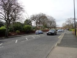
The C512 is the number now used for the former route of the B1405 in Sunderland. It begins at a roundabout on the B1522 (formerly the A1018, and prior to that the A19) in Grangetown, setting off in a north-westerly direction along Queen Alexandra Road, through a mostly residential area. The road is wide, a hint of its identity as a former Class II road. It passes the Sunderland Eye Infirmary on the right and goes through a roundabout, where it crosses the C514 Tunstall Road. It continues along Queen Alexandra Road until reaching the A690 at the Barnes gyratory.
From here the C512 turns to head north alongside Barnes Park, then leaving the park behind follows Ormonde Street to a traffic light controlled crossroads on the A183. It continues north past Sunderland Hospital and passes through a further light controlled crossroads, then becomes the main road through Pallion, flanked by various shops and takeaways and passing numerous speed humps and zebra crossings.
Northbound traffic soon has to take a sharp left turn as the road enters a gyratory, followed quickly by a sharp right. The gyratory, bizarrely, plays host to a green sign despite never having been an A-road, let alone primary. Northbound and southbound traffic reconvene and the road dips down underneath a former railway line before ending at a junction on the B1405 near Pallion Metro station. This junction, a former roundabout, was extensively remodelled in 2017 in preparation for the construction of the Northern Spire, and formed part of the temporary tie-in linking the new bridge with the A1231 towards the city centre. Today, however, the bridge cannot be accessed directly from this junction.
| C512 (Sunderland) | ||||||||||||
| ||||||||||||
|


