Star.pngStar.pngStar.pngStar grey.pngStar grey.png

Drum Bridge

From Roader's Digest: The SABRE Wiki
Jump to navigation Jump to search
Drum Bridge
Location Map ( geo)
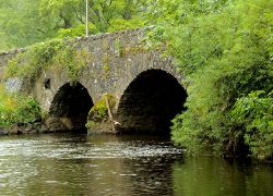
The Drum Bridge, Drumbeg (2) - Geograph - 3062075.jpg
The bridge in 2012
Cameraicon.png View gallery (1)
Location
Drumbeg
County
Down • Antrim
Highway Authority
DfI Roads
Opening Date
before 1832
Additional Information
List No:  HB26/16/012  (Cat B1)
Bridge Type:  Arch Bridge
On road(s)
B103
Crossings related to the B103 (Northern Ireland)

Drum Bridge carries the B103 across the River Lagan at Drumbeg, to the south of Belfast. It is a stone arch bridge, with three principal arches, and six flood arches. The road deck has two traffic lanes and narrow pedestrian provision.

The bridge (and neighbouring canal bridge) are both listed, with Drum Bridge being constructed prior to 1832[1].

References


Drum Bridge
Related Pictures
View gallery (1)
The Drum Bridge, Drumbeg (2) - Geograph - 3062075.jpg
Crossings of the River Lagan
Lagan Bridge • Queen Elizabeth II Bridge • Queens Bridge (Belfast) • Albert Bridge • Ormeau Bridge • Kings Bridge • Governors Bridge • Shaw's Bridge • Drum Bridge • M1 Bridge • Wolfenden's Bridge • Lambeg Bridge • Hilden Bridge • Queens Bridge (Lisburn) • Union Bridge • Moore's Bridge • Young's Bridge • Maze Bridge • The New Bridge • Spencer's Bridge • Newmill Bridge • Steps Bridge • New Forge Bridge • Geehan's Bridge • Banoge Bridge • Donaghcloney Bridge • Thornyford Bridge • Gillhall Bridge • A1 • Regent Bridge • Downshire Bridge • Lagangreen Bridge • Black Bog Road Bridge • Bell's Bridge • Dree Hill Road Bridge


SABRE - The Society for All British and Irish Road Enthusiasts
Discuss - Digest - Discover - Help