Star.pngStar.pngStar grey.pngStar grey.pngStar grey.png

Michael Collins Bridge

From Roader's Digest: The SABRE Wiki
Jump to navigation Jump to search
Michael Collins Bridge
Droichead Mícheál Ó Coileáin
Location Map ( geo)
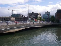
20180824-1509 - Michael Collins Bridge from Penrose Quay 51.900209N 8.463782W.jpg
View of the bridge from Penrose Quay
Cameraicon.png View gallery (2)
From:  Penrose Quay
To:  Anderson's Quay
County
Cork
Highway Authority
Transport Infrastructure Ireland
On road(s)
N27

Michael Collins Bridge carries the N27 and the Cork City Inner Orbital Route across the Lee in the centre of Cork.

In planning, it was referred to as one of the Custom House Bridges.


Michael Collins Bridge
Related Pictures
View gallery (2)
20180824-1508 - Michael Collins Bridge from Penrose Quay 51.900321N 8.464415W.jpg20180824-1509 - Michael Collins Bridge from Penrose Quay 51.900209N 8.463782W.jpg
Crossings of the River Lee
Upstream from CorkDromcarra Bridge • Coolcower Bridge • Innishcarra Bridge • Leemount Bridge
Cork (North Channel)Thomas Davis Bridge • Mardyke Bridge (P) • St Vincents Bridge (P) • Griffith Bridge • Shandon Bridge (P) • Christy Ring Bridge • St Patricks Bridge • Harley's Street Bridge (P) • Brian Boru Bridge • Michael Collins Bridge
Cork (South Channel)St Finnbarres Bridge • Clarkes Bridge • South Gate Bridge • Parliament Bridge • Parnell Bridge • Clontarf Bridge • Eamon De Valera Bridge
Downstream from CorkJack Lynch Tunnel • Passage West Ferry


SABRE - The Society for All British and Irish Road Enthusiasts
Discuss - Digest - Discover - Help