Old USGS imagery showing former road layouts
Moderator: Site Management Team

Re: Old USGS imagery showing former road layouts

Re: Old USGS imagery showing former road layouts
There was previously a railway line on roughly the alignment of the modern A34. I'd imagine it closed during the early-mid 1960s, which was when quite a lot of less major railway lines ceased operation.
See my Geograph profile here - http://www.geograph.org.uk/profile/74193
The Swindon Files - Swindon's modern history - http://rjdg14.altervista.org/swindon/
----
If I break a policy designed only to protect me and nobody else, have I really broken anything?
Re: Old USGS imagery showing former road layouts

Re: Old USGS imagery showing former road layouts
Re: Old USGS imagery showing former road layouts
Mostly the "Declass 3" one, which consists of high resolution KH9 satellite imagery taken mostly during the 1970s. As I said earlier, only a small proportion of imagery in the dataset is currently available to download on demand because many of the negatives haven't been digitised at a high resolution, but these ones were available.
The two Northern Irish ones were sourced from the Declass 2 dataset, which consists mostly of lower resolution imagery.
There looks to be a small amount of downloadable Declass 3 KH9 imagery from 1982 of southern Scotland, but there is a lot of cloud cover so I don't really think it's worth me downloading for analysis.
See my Geograph profile here - http://www.geograph.org.uk/profile/74193
The Swindon Files - Swindon's modern history - http://rjdg14.altervista.org/swindon/
----
If I break a policy designed only to protect me and nobody else, have I really broken anything?
-
JackieRoads

- Member
- Posts: 489
- Joined: Sat Jan 25, 2020 14:49
Re: Old USGS imagery showing former road layouts
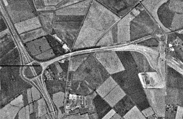
Can I request one thing? The request is St Georges Interchange or M5 J21. It should have opened around that time.RJDG14 wrote: ↑Tue Jul 25, 2023 09:28Mostly the "Declass 3" one, which consists of high resolution KH9 satellite imagery taken mostly during the 1970s. As I said earlier, only a small proportion of imagery in the dataset is currently available to download on demand because many of the negatives haven't been digitised at a high resolution, but these ones were available.
The two Northern Irish ones were sourced from the Declass 2 dataset, which consists mostly of lower resolution imagery.
There looks to be a small amount of downloadable Declass 3 KH9 imagery from 1982 of southern Scotland, but there is a lot of cloud cover so I don't really think it's worth me downloading for analysis.
As a wise roadie said, don't make any mistakes in building roads.
Re: Old USGS imagery showing former road layouts
See my Geograph profile here - http://www.geograph.org.uk/profile/74193
The Swindon Files - Swindon's modern history - http://rjdg14.altervista.org/swindon/
----
If I break a policy designed only to protect me and nobody else, have I really broken anything?
Re: Old USGS imagery showing former road layouts
Here we are. It looked much the same as now (aside from the road heading into Weston Super Mare not being fully dualled) but did look fairly new:JackieRoads wrote: ↑Tue Jul 25, 2023 09:33Can I request one thing? The request is St Georges Interchange or M5 J21. It should have opened around that time.RJDG14 wrote: ↑Tue Jul 25, 2023 09:28Mostly the "Declass 3" one, which consists of high resolution KH9 satellite imagery taken mostly during the 1970s. As I said earlier, only a small proportion of imagery in the dataset is currently available to download on demand because many of the negatives haven't been digitised at a high resolution, but these ones were available.
The two Northern Irish ones were sourced from the Declass 2 dataset, which consists mostly of lower resolution imagery.
There looks to be a small amount of downloadable Declass 3 KH9 imagery from 1982 of southern Scotland, but there is a lot of cloud cover so I don't really think it's worth me downloading for analysis.
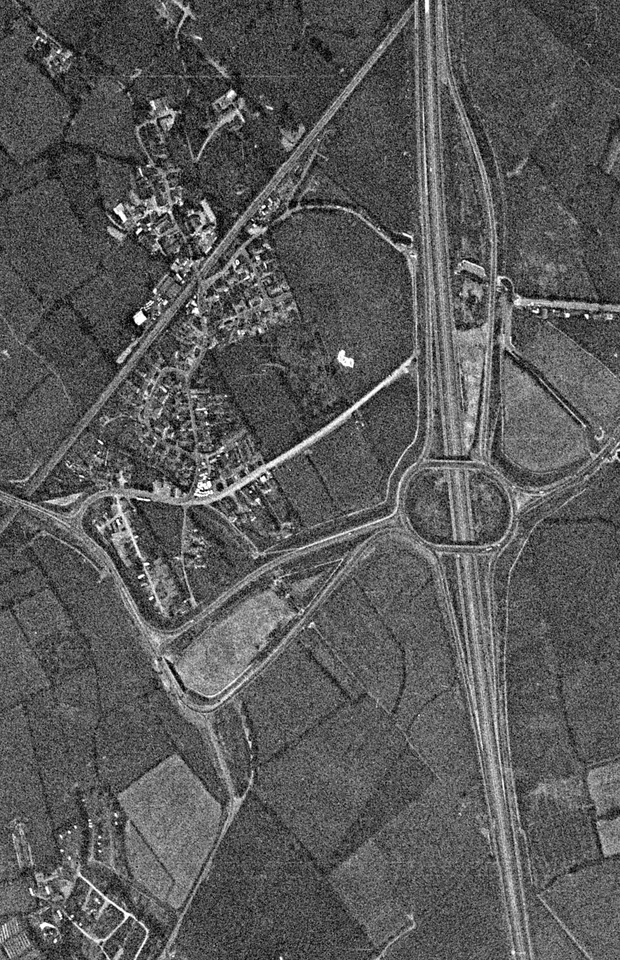
By the way, what's up with that rather weird split lane layout on what I assume to be the A370? It looks like some sort of future road provision proofing.
From what I can tell based on the 1973 imagery, most of the M5 was completed or in the final stages of completion by 1973 with the exception of the Avonmouth Bridge which was in the earlier stages of construction.
See my Geograph profile here - http://www.geograph.org.uk/profile/74193
The Swindon Files - Swindon's modern history - http://rjdg14.altervista.org/swindon/
----
If I break a policy designed only to protect me and nobody else, have I really broken anything?

Re: Old USGS imagery showing former road layouts
RJDG14 wrote: ↑Tue Jul 25, 2023 10:11Here we are. It looked much the same as now (aside from the road heading into Weston Super Mare not being fully dualled) but did look fairly new:JackieRoads wrote: ↑Tue Jul 25, 2023 09:33Can I request one thing? The request is St Georges Interchange or M5 J21. It should have opened around that time.RJDG14 wrote: ↑Tue Jul 25, 2023 09:28
Mostly the "Declass 3" one, which consists of high resolution KH9 satellite imagery taken mostly during the 1970s. As I said earlier, only a small proportion of imagery in the dataset is currently available to download on demand because many of the negatives haven't been digitised at a high resolution, but these ones were available.
The two Northern Irish ones were sourced from the Declass 2 dataset, which consists mostly of lower resolution imagery.
There looks to be a small amount of downloadable Declass 3 KH9 imagery from 1982 of southern Scotland, but there is a lot of cloud cover so I don't really think it's worth me downloading for analysis.
By the way, what's up with that rather weird split lane layout on what I assume to be the A370? It looks like some sort of future road provision proofing.
From what I can tell based on the 1973 imagery, most of the M5 was completed or in the final stages of completion by 1973 with the exception of the Avonmouth Bridge which was in the earlier stages of construction.
I will omit the traditional 'sheesh' but its in the wiki
[quote=''https://www.sabre-roads.org.uk/wiki/ind ... title=A370]
Section 2: Weston-super-Mare – East Brent
From one GSJ, the A370 quickly reaches another, just off the motorway junction. The A370 used to turn off here, over a future proofed bridge and run through Worle on what is now the B3440 (a duplicated number from Devon!), but a new dual carriageway known as "Somerset Avenue" now keeps traffic out of the built-up area, with roundabouts providing access to local roads, the A371, and the absurd A3033 - a ridiculously short road whose only purpose is to connect the A370 to itself. The new section of road terminates at Tescos, after crossing the railway and just short of the sea front. A loop round the town hall leads onto the beach lawns, where the A370 abruptly turns left and follows the front, losing primary status once more.
[/quote]
From the SABRE Wiki: A370 :
The A370 is a route which heads south west from Bristol to the coastal resort of Weston-super-Mare, and then continues south to rejoin the A38. As such, it can be considered a "long-way-around" route - to travel from one end to the other it would be more direct and probably quicker to take the A38. In many cases such circuitous routes are caused by extension of a pre-existing number, but in this case it appears that the A370 had essentially the same route as it had in the
Re: Old USGS imagery showing former road layouts
See my Geograph profile here - http://www.geograph.org.uk/profile/74193
The Swindon Files - Swindon's modern history - http://rjdg14.altervista.org/swindon/
----
If I break a policy designed only to protect me and nobody else, have I really broken anything?
Re: Old USGS imagery showing former road layouts
RJDG14 wrote: ↑Tue Jul 25, 2023 10:11Here we are. It looked much the same as now (aside from the road heading into Weston Super Mare not being fully dualled) but did look fairly new:JackieRoads wrote: ↑Tue Jul 25, 2023 09:33Can I request one thing? The request is St Georges Interchange or M5 J21. It should have opened around that time.RJDG14 wrote: ↑Tue Jul 25, 2023 09:28
Mostly the "Declass 3" one, which consists of high resolution KH9 satellite imagery taken mostly during the 1970s. As I said earlier, only a small proportion of imagery in the dataset is currently available to download on demand because many of the negatives haven't been digitised at a high resolution, but these ones were available.
The two Northern Irish ones were sourced from the Declass 2 dataset, which consists mostly of lower resolution imagery.
There looks to be a small amount of downloadable Declass 3 KH9 imagery from 1982 of southern Scotland, but there is a lot of cloud cover so I don't really think it's worth me downloading for analysis.
By the way, what's up with that rather weird split lane layout on what I assume to be the A370? It looks like some sort of future road provision proofing.
From what I can tell based on the 1973 imagery, most of the M5 was completed or in the final stages of completion by 1973 with the exception of the Avonmouth Bridge which was in the earlier stages of construction.
I will omit the traditional 'sheesh' but its in the wiki
[quote=''https://www.sabre-roads.org.uk/wiki/ind ... title=A370]
Section 2: Weston-super-Mare – East Brent
From one GSJ, the A370 quickly reaches another, just off the motorway junction. The A370 used to turn off here, over a future proofed bridge and run through Worle on what is now the B3440 (a duplicated number from Devon!), but a new dual carriageway known as "Somerset Avenue" now keeps traffic out of the built-up area, with roundabouts providing access to local roads, the A371, and the absurd A3033 - a ridiculously short road whose only purpose is to connect the A370 to itself. The new section of road terminates at Tescos, after crossing the railway and just short of the sea front. A loop round the town hall leads onto the beach lawns, where the A370 abruptly turns left and follows the front, losing primary status once more.
[/quote]
It caught me by surprise about 5 years ago as I hadn't been into Weston since the mid 1970's, I was trying to get to the helicopter museum.
From the SABRE Wiki: A370 :
The A370 is a route which heads south west from Bristol to the coastal resort of Weston-super-Mare, and then continues south to rejoin the A38. As such, it can be considered a "long-way-around" route - to travel from one end to the other it would be more direct and probably quicker to take the A38. In many cases such circuitous routes are caused by extension of a pre-existing number, but in this case it appears that the A370 had essentially the same route as it had in the
-
zapalniczka

- Member
- Posts: 649
- Joined: Mon Oct 15, 2012 14:56
Re: Old USGS imagery showing former road layouts
-
JackieRoads
- Member
- Posts: 489
- Joined: Sat Jan 25, 2020 14:49
Re: Old USGS imagery showing former road layouts
Indeed it was. According to the wiki page of the interchange, the A370 was dualled from the motorway into the town centre, meaning I think there were new roundabouts built all the way, into the retail park area. And it's quite interesting seeing all of this.RJDG14 wrote: ↑Tue Jul 25, 2023 10:11Here we are. It looked much the same as now (aside from the road heading into Weston Super Mare not being fully dualled) but did look fairly new:JackieRoads wrote: ↑Tue Jul 25, 2023 09:33Can I request one thing? The request is St Georges Interchange or M5 J21. It should have opened around that time.RJDG14 wrote: ↑Tue Jul 25, 2023 09:28
Mostly the "Declass 3" one, which consists of high resolution KH9 satellite imagery taken mostly during the 1970s. As I said earlier, only a small proportion of imagery in the dataset is currently available to download on demand because many of the negatives haven't been digitised at a high resolution, but these ones were available.
The two Northern Irish ones were sourced from the Declass 2 dataset, which consists mostly of lower resolution imagery.
There looks to be a small amount of downloadable Declass 3 KH9 imagery from 1982 of southern Scotland, but there is a lot of cloud cover so I don't really think it's worth me downloading for analysis.
By the way, what's up with that rather weird split lane layout on what I assume to be the A370? It looks like some sort of future road provision proofing.
From what I can tell based on the 1973 imagery, most of the M5 was completed or in the final stages of completion by 1973 with the exception of the Avonmouth Bridge which was in the earlier stages of construction.
As a wise roadie said, don't make any mistakes in building roads.
-
Chris Bertram

- Member
- Posts: 15778
- Joined: Tue Nov 13, 2001 12:30
- Location: Birmingham, England
Re: Old USGS imagery showing former road layouts
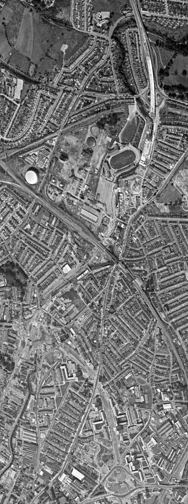
I see Eastville stadium there, the former home of Bristol Rovers FC, now demolished. The nearby gasworks gave the team the unofficial nickname of "The Gas" with fans known as "Gasheads" (the official nickname is "The Pirates", but where's the fun in that?). Rovers left the stadium and spent some years playing in Bath as the tenants of Bath City FC, but now play at the Memorial Stadium, the former home of Bristol RFC, who ironically now share Ashton Gate stadium with Bristol City FC.
Did you know there's more to SABRE than just the Forums?
Add your roads knowledge to the SABRE Wiki today!
Have you browsed SABRE Maps recently? Try getting involved!
-
Steven

- SABRE Maps Coordinator
- Posts: 19257
- Joined: Tue Feb 12, 2002 20:39
- Location: Wolverhampton, Staffordshire
- Contact:
Re: Old USGS imagery showing former road layouts
The A370 split and the M5 junction design is for the Weston-super-Mare Spur.
Motorway Historian
Founder Member, SABRE ex-Presidents' Corner
Add your roads knowledge to the SABRE Wiki today!
Have you browsed SABRE Maps recently? Try getting involved!
-
JackieRoads
- Member
- Posts: 489
- Joined: Sat Jan 25, 2020 14:49
Re: Old USGS imagery showing former road layouts
Which wasn't eventually built.
As a wise roadie said, don't make any mistakes in building roads.
Re: Old USGS imagery showing former road layouts
The modern A370 I believe does use the washed up remains of the Weston-Super-Mare Spur, at least as far as this provisional layout is concerned. Likewise the Long Ashton Bypass is based on the washed up remains of the South Bristol Spur.
See my Geograph profile here - http://www.geograph.org.uk/profile/74193
The Swindon Files - Swindon's modern history - http://rjdg14.altervista.org/swindon/
----
If I break a policy designed only to protect me and nobody else, have I really broken anything?
-
GillsPeter
- Member
- Posts: 31
- Joined: Sat Apr 01, 2023 18:50
Re: Old USGS imagery showing former road layouts
-
JackieRoads
- Member
- Posts: 489
- Joined: Sat Jan 25, 2020 14:49
Re: Old USGS imagery showing former road layouts
As a wise roadie said, don't make any mistakes in building roads.
-
ForestChav

- SABRE Developer
- Posts: 11126
- Joined: Sat Sep 24, 2005 00:00
- Location: Nottingham (Bronx of the Midlands)
- Contact:
Re: Old USGS imagery showing former road layouts
Bring what back? All RJDG14 did was download something the USGS have made public, anyone can do it?JackieRoads wrote: ↑Sat Aug 05, 2023 21:05 Speaking of which, should we bring this back so we can see some more old layouts in old images? It's been 11 days.
Never argue with an idiot. They will bring you down to their level and beat you with experience.