Bristol
For the Highway Authority, see Bristol Council.
Bristol is the sixth largest city in England lying in the West Country and having major docks on the River Avon. It is unusual in that it is both split across two historic counties, Gloucestershire and Somerset, and has a Lord Lieutenant in its own right - the latter being based upon its former status as a County Corporate, an early form of County Borough.
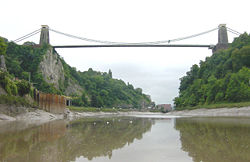
There are several important bridges in the Bristol area, including the Clifton Suspension Bridge, the Avonmouth Bridge and the Bedminster Bridge, as well as Gordano Services on the M5. The Almondsbury Interchange between M5 and M4 is located to the northwest of the city.
History
The pre-numbering road network in Bristol was based around the city centre and the historic harbour, which was a major regional centre for shipping. In the turn of the 20th century, the port of Avonmouth became increasingly important, as it could cope with larger cargo. This led to the construction of the Portway in the 1920s; the road is still important today and used as a major route from the M5 to the city centre.
A brief comparison of the two maps to the left will show just how much the road network of Bristol developed in the 1930s - little would have been achieved in the immediate post-war years. In the last fifty years there have been even more changes - the arrival of the motorways for starters, not to mention the grand schemes of the A4044 and A4174 - the first partly dismantled and the second still incomplete!
A major development in the inter-war years was turning Queen Square into a dual carriageway, allowing the A4 to bypass the historic city centre. Since then, the idea of destroying a historic Georgian square and park into a road has become so unpopular, that this route was eventually ripped up and the land returned to its original 18th century layout, all for the better.
One of the major developments was the Filton Bypass, in an attempt to improve traffic coming from the A38 to get to the city centre while avoiding areas such as Filton. However, this road was later abandoned as Filton Airfield was expanded and Bristol became an important city for aerospace engineering and development. Instead, the first part of the M5 was built, connecting the A38 to Cribbs Causeway, allowing traffic to reach the city centre via Henbury and Westbury on Trym.
The M32 was built between 1966 and 1975, in order to provide the main route into the city.
Another project indicating how much Bristol has changed its opinion about road traffic was the Redcliffe Flyover, that was a temporary link near Temple Meads station and part of the Inner Ring Road. It was demolished not longer after the restoration of Queen Square.
Routes
| Route | To | Notes |
| The MIDLANDS, SOUTH WALES,Gloucester, Cheltenham, (Chepstow), (M4) | For South Wales (M4 West), the M49 can be used. From the City Centre, the M32 can be used for the M4. | |
| The SOUTH WEST, Bridgwater, Taunton | ||
| The MIDLANDS, SOUTH WALES, (Swindon), (Reading), London, (M4) | Bristol City Centre to M4 via Bristol Parkway Railway Station and Northern Bristol, as well as Ring Road. | |
| SOUTH WALES, Newport, Cardiff, (M4) | From M5/A4 to M4 with no other junctions. Second Severn Crossing (M4 West) requires Toll Money. No access to M48/Chepstow/Services, use M5 | |
| Bath | ||
| Avonmouth, (M49) | ||
| Shepton Mallet, Wells (A39) | ||
| Taunton, Bristol Airport | ||
| Bristol Ring Road | Incomplete Ring. From M32 around the Eastern, Northern and Southern of Bristol. | |
| Patchway, Gloucester (M4, M5) | ||
| Portishead | ||
| Weston-super-Mare | ||
| Kingswood, Chippenham | ||
| Hanham, Bath | ||
| Fishponds, Stapleton, Horfield (M32, M4, M5) | ||
| Westbury on Trym, Gloucester (A38) (M4, M5, M32) | ||
| Clevedon | ||
| Stoke Bishop | ||
| Severn Beach | ||
| Iron Acton | ||
| Dodington Ash |
| Bristol | ||||||||
| ||||||||
| ||||||||
| ||||||||
| ||||||||
| ||||||||
| ||||||||
| ||||||||
|


