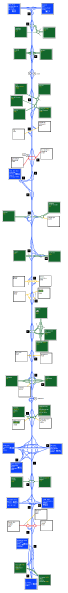
This is a strip map of my M12. It starts at M11 J4, using the existing layout as a basis, and goes out towards Chelmsford and Ipswich, before heading up to Norwich and terminating on my fantasy M17.
Location:
This picture currently has no coords, edit this page to add them.
This is a strip map of my M12. It starts at M11 J4, using the existing layout as a basis, and goes out towards Chelmsford and Ipswich, before heading up to Norwich and terminating on my fantasy M17.
