Gallery:NCN6
The Outwood Trail is a route for walkers, cyclists and horseriders along the former Lancashire & Yorkshire Railway line through ancient clough woodlands between Radcliffe and Prestwich. It forms part of the Irwell Sculpture Trail and National Route 6 of the Sustrans cycle network.
National Cycle Route 6 enters Manchester from Reddish via the traffic-free former Fallowfield Loop Line and then on residential streets through Whalley Range into the city centre.
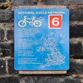
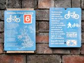
Sign attached to the bridge at Nelstrop Road (<a href='http://www.geograph.org.uk/photo/3215462'>SJ8894 : Fallowfield Loop Line, Bridge#14 (Nelstrop Road)</a>). It reads:
This is part of the National Cycle
Network. This 10,000 mile project
is being developed by a partnership
of local authorities and others,
and is co-ordinated by the
charity Sustrans.
As far as possible, the National Cycle Network
follows quiet roads or purpose
built traffic-free paths to avoid
main roads. It aims to
connect the centre of
each town along the way.
Traffic free sections are
used by walkers, cyclists
and sometimes horses.
Please respect other users.
For more information on routes
in your area contact Sustrans
0117 929 0888 or visit
Sign attached to the bridge at Longford Road West (<a href='http://www.geograph.org.uk/photo/3215473'>SJ8894 : Fallowfield Loop Line, Bridge at Longford Road East</a>). The one on the left hand side reads:
This is part of the National Cycle
Network. This 10,000 mile project
is being developed by a partnership
of local authorities and others,
and is co-ordinated by the
charity Sustrans.
As far as possible, the National Cycle Network
follows quiet roads or purpose
built traffic-free paths to avoid
main roads. It aims to
connect the centre of
each town along the way.
Traffic free sections are
used by walkers, cyclists
and sometimes horses.
Please respect other users.
For more information on routes
in your area contact Sustrans
0117 929 0888 or visit
<a title='www.nationalcyclenetwork.org.uk' rel='nofollow' href='http://www.nationalcyclenetwork.org.uk'>Link</a><img style='padding-left:2px;' alt='External link' title='External link - shift click to open in new window' src='http://s1.geograph.org.uk/img/external.png' width='10' height='10'/>
The one on the right reads:
Sustrans has
negotiated
this route for
the use of non-
motorised
travellers only.
It is a permissive
path by kind
permission of
the landowner.
It is not a public
right of way.
For information
Sustrans
