Lagan Bridge
Jump to navigation
Jump to search
| Lagan Bridge | |||
| Location Map ( geo) | |||
 | |||
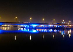
| The rail and road bridges at night | |||
| |||
| From: | Belfast | ||
| To: | Ballymacarret | ||
| Location | |||
| Belfast | |||
| County | |||
| Antrim • Down | |||
| Highway Authority | |||
| DfI Roads | |||
| Opening Date | |||
| 1995 | |||
| Additional Information | |||
| |||
| On road(s) | |||
| M3 | |||
This article is about the current motorway bridge.
For the Albert Bridge, where a former bridge known as the Lagan Bridge stood on the same site, see Albert Bridge (Belfast).
For the Albert Bridge, where a former bridge known as the Lagan Bridge stood on the same site, see Albert Bridge (Belfast).
The Lagan Bridge carries eight traffic lanes of the M3 Motorway, next to the Dargan Bridge, which has the Belfast York Road railway line on it.
The bridge is the furthest downstream crossing point of the Lagan before it reaches the sea.
| Lagan Bridge | ||
| ||
|


