Star.pngStar.pngStar grey.pngStar grey.pngStar grey.png

Mount Garrett Bridge

From Roader's Digest: The SABRE Wiki
Jump to navigation Jump to search
Mount Garrett Bridge
Location Map ( geo)
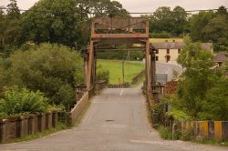
Former lifting bridge over the River Barrow at Ferrymountgarrett - Geograph - 202307.jpg
Picture of the bridge taken in 2006
Cameraicon.png View gallery (1)
Location
Kylemore
County
Wexford • Kilkenny
Highway Authority
Wexford County • Kilkenny County
Opening Date
1925-30
Additional Information
Bridge Type:  Bascule Bridge
Engineer:  Alfred Dover Delap
On road(s)
R700

Mount Garrett Bridge carries the R700 over the River Barrow between the counties of Wexford and Kilkenny, at Kylemore, to the north of New Ross.

Construction commenced in 1925, and the bridge was opened in 1930. It replaced a wooden bridge, constructed in 1794 and destroyed as part of the independence movement in 1921.

Links


Mount Garrett Bridge
Related Pictures
View gallery (1)
Former lifting bridge over the River Barrow at Ferrymountgarrett - Geograph - 202307.jpg
Crossings of the River Barrow
Tinnahinch Bridge • Rathcoffey Bridge • Ballyclare Bridge • Mucklone Bridge • Twomile Bridge • Bay Bridge • Borness Bridge • Clonterry Bridge • Portnahinch Bridge • Kilnahown Bridge • Portarlington Bridge • Spa Bridge • Baylough Bridge • Pass Bridge • Monasterevin Town Bridge • M7 Bridge • Dunrally Bridge • Bert Bridge • Crom-a-Boo Bridge • Tankardstown Bridge • Maganey Bridge • Bill Duggan Bridge • Graiguecullen Bridge • Milford Bridge • M9 Bridge • Cardinal Moran Bridge • The Valerian Bridge • Royal Oak Bridge • Gores Bridge • Ballyteigelea Bridge • Graiguenamanagh Bridge • Mount Garrett Bridge • O'Hanrahan Bridge • Rose Fitzgerald Kennedy Bridge

SABRE - The Society for All British and Irish Road Enthusiasts
Discuss - Digest - Discover - Help