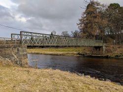
Raigbeg Bridge
| Raigbeg Bridge | |||
| Location Map ( geo) | |||
 | |||
| |||
| Location | |||
| Tomatin | |||
| County | |||
| Inverness-shire | |||
| Highway Authority | |||
| Highland | |||
Raigbeg Bridge crosses the River Findhorn near the village of Tomatin. The bridge is on the line of General Wade's military road and the first bridge at the location was a three arch stone bridge built by General Barrington to replace earlier fords. That bridge was destroyed by floods in 1829 and local landowners paid to have a temporary wooden bridge erected just downstream.
The current bridge is the third at this location and is constructed of cast iron lattice sides with a timber deck. The roadway is single track with a 3 tonne weight limit with a restiction of on a single vehicle to be on the bridge at a time. The road is unclassified and numbered as U2829.
The bridge was superseded by a new crossing, further upstream, built by Thomas Telford in 1833, on the site of the current Findhorn Bridge.
| Raigbeg Bridge | ||||||||
| ||||||||
|


