File:1971 Strip Map of the A74 I - Coppermine - 2242.JPG
Jump to navigation
Jump to search


Size of this PNG preview of this JPG file: 199 × 600 pixels.
Original file (437 × 1,317 pixels, file size: 1.65 MB, MIME type: image/x-ms-bmp)
| ||||||||||||||
|
Galleries | A74 | M6 | Cumberland Gap | ||
File history
Click on a date/time to view the file as it appeared at that time.
| Date/Time | Thumbnail | Dimensions | User | Comment | |
|---|---|---|---|---|---|
| current | 13:43, 16 January 2012 | 437 × 1,317 (1.65 MB) | Abeaton (talk | contribs) | Updated to Modern standards | |
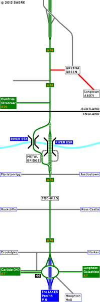
| 17:46, 31 March 2010 | 298 × 744 (37 KB) | Rileyrob (talk | contribs) | '''1971 Strip Map of the A74 I''' This strip map of the A74 is based in 1971. The Cumberland Gap was S2. Gretna was yet to be by-passed. The M6 has just opened. This means Carlisle has been by-passed & the South of England & the A66 is easier to reach no |
File usage
There are no pages that use this file.