File:A1021 (Buckden - Brampton)-map.png
Jump to navigation
Jump to search

No higher resolution available.
A1021_(Buckden_-_Brampton)-map.png (127 × 212 pixels, file size: 65 KB, MIME type: image/png)
| |||||||||||||||||||||||||
|
Galleries | A1021 (Buckden - Brampton) | A1 | A604 | Brampton Hut | Ten-Mile Road Map of Great Britain | ||
File history
Click on a date/time to view the file as it appeared at that time.
| Date/Time | Thumbnail | Dimensions | User | Comment | |
|---|---|---|---|---|---|
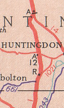
| current | 17:16, 4 February 2010 | | 127 × 212 (65 KB) | Ritchie333 (talk | contribs) | {{Information |description = A1021 cutting the corner between the A1 and the A604 near Brampton |day = |month = |year = 1932 |photographer = Ordnance Survey 10 inch / mile road map |source = Ordnance Survey |road = |
File usage
The following 2 pages use this file:
-map.png&oldid=619225)