Foula Ferry
Jump to navigation
Jump to search
| Foula Ferry | |||
| Location Map ( geo) | |||
 | |||
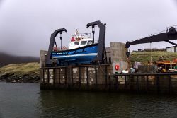
| The ferry "New Advance" in its cradle between sailings | |||
| |||
| From: | Walls | ||
| To: | Foula | ||
| Distance: | 29.2 km (18.1 miles) | ||
| County | |||
| Zetland | |||
The Foula Ferry provides a link to Foula from Walls, on Shetland. The journey takes about two and a quarter hours and operates two to three return crossings per week from the island.
In common with the Fair Isle Ferry, the Foula ferry boat is lifted out of the water between crossings, by means of a cradle.
Ferries
| Name | IMO | Operator | Dates | Notes |
|---|---|---|---|---|
| New Advance | 9086813 | BK Marine | 1996-date | 12 passengers |
| Good Shepherd IV | Shetland Islands Council | ?-1996 | 1 car via crane - No IMO MarineTraffic | |
| Kaoda | ?-1996 | |||
| Westering Homewards | ||||
| Melvin |
Links
| Foula Ferry | ||||||||
| ||||||||
|


