Gallery:Port Erin
From Roader's Digest: The SABRE Wiki
Jump to navigation
Jump to search
Isle of Man > Port Erin
This gallery has no child categories
Port Erin
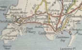
The A33 between Port St Mary and Port Erin This page includes a scan of a non-free copyrighted map, and the copyright for it is most likely held by the company or person that produced the map. It is believed that the use of a limited number of web-resolution scans qualifies as fair use under United States copyright law, where this web page is hosted, as such display does not significantly impede the right of the copyright holder to sell the copyrighted material, is not being used to generate profit in this context, and presents information that cannot be exhibited otherwise.
If the copyright holder considers this is an infringement of their rights, please contact the Site Management Team to discuss further steps.
If the copyright holder considers this is an infringement of their rights, please contact the Site Management Team to discuss further steps.
Entering Port Erin (C) Anne and Jeff Rolfe
Entering Port Erin on the A7 from Colby
Entering Port Erin on the A7 from Colby
Port Erin - Shore Road wall and... (C) Joseph Mischyshyn
Shore Road leads to Port Erin Bay. View is to the north from near the south end of the road. The building to the near right has a life preserver on it marked
Shore Road leads to Port Erin Bay. View is to the north from near the south end of the road. The building to the near right has a life preserver on it marked
'Water Edge'. The buildings shown in the far distance are along Promenade on the
Droghadfayle Road, Port Erin, Isle of... (C) kevin rothwell
Royal British Legion building alongside Methodist Church.
Royal British Legion building alongside Methodist Church.
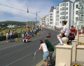
Soapbox Derby, Port Erin, Isle of Man (C) kevin rothwell
On Spaldrick Promenade.
A lot of time and effort is spent preparing for this event which draws huge crowds.
On Spaldrick Promenade.
A lot of time and effort is spent preparing for this event which draws huge crowds.
Hidden categories:


