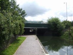
Gorsebrook Bridge
Jump to navigation
Jump to search
| Gorsebrook Bridge | |||||
| Location Map ( geo) | |||||
 | |||||
| Location | |||||
| Dunstall, Wolverhampton | |||||
| County | |||||
| Staffordshire | |||||
| Highway Authority | |||||
| Wolverhampton | |||||
| Opening Date | |||||
| 1960s | |||||
| Additional Information | |||||
| |||||
| On road(s) | |||||
| A449 | |||||
Gorsebrook Bridge was reconstructed in the 1960s when this section of A449 was expanded into a dual carriageway.
It carries the A449 over the Birmingham Canal, and has particularly low headroom under the bridge, especially on the eastern side where there is a lock - the height of the top of the lock is at the height of the bridge.
| Gorsebrook Bridge | ||
|

