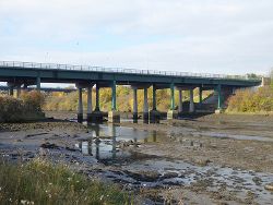
Kitty Brewster Bridge
| Kitty Brewster Bridge | |||
| Location Map ( geo) | |||
 | |||
| Image showing both the old and new bridges | |||
| |||
| Location | |||
| Blyth | |||
| County | |||
| Northumberland | |||
| Highway Authority | |||
| Northumberland | |||
| Opening Date | |||
| 1960 (Southbound), 1996 (Northbound) | |||
| On road(s) | |||
| A189 | |||
| Crossings related to the A189 | |||
Kitty Brewster Bridge carries the A189 South-east Northumberland Spine Road over the River Blyth t0 the west of the town of the same name.
History
The nearest upstream crossing of the River Blyth was originally the narrow Furnace Bridge by Bedlington Bank.
Kitty Brewster Bridge and the link from Bebside (A193) to Moorland Avenue, Bedlington Station was to be opened on 15 April 1961 by Alderman Dan Dawson. It had 5 spans of 80 feet and carried a 33 foot wide carriageway 40 foot above the river. Bridge contractor was Brims and Co. of Newcastle and Middlesborough who had also reconstructed the nearby Furnace Bridge in 1910. Tender price was £116,130.
It opened as B1330 but became A189 after the Spine Road extension north of Bedlington Station was opened in 1975.
The crossing was originally just one bridge (today's southbound carriageway). The newer bridge which carries northbound traffic was opened in 1996.
| Kitty Brewster Bridge | ||
|
