The study of British and Irish roads - their construction, numbering, history, mapping, past and future official roads proposals and general roads musings.
There is a separate forum for Street Furniture (traffic lights, street lights, road signs etc).
Registered users get access to other forums including discussions about other forms of transport, driving, fantasy roads and wishlists, and roads quizzes.
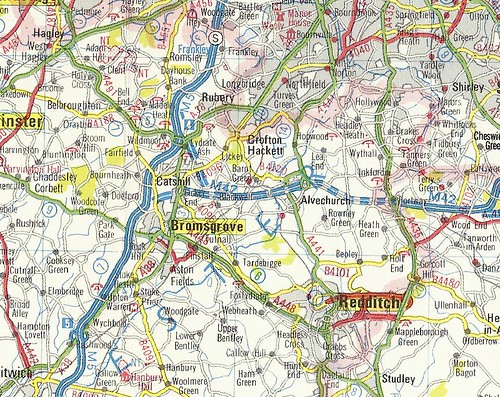
I was going through and re-scanning some of my maps recently and noticed one that showed the A4189 as complete in Redditch, with the trumpet-style junction in place and the route north to the Coventry Highway there too. Bearing in mind this map was printed in 1984, that seems pretty late in the day to make an error like that? Or were the plans for Redditch still in existence at that point?
Chris Bertram wrote:I wonder where the DC at the north heading out along the line of Icknield (Rykneld) Street was supposed to go. Carry on along there and eventually you end up in Kings Norton, but there's no indication of a connection up there, and in between is all country lanes, with the exception of the M42.
I've no idea where it was supposed to go as the planning maps end where mine does but a guess may be it was an earlier version of the Alvechurch Bypass. It points slighty west of due north which is exactly the direction of M42 J2. All the major expresssways are given the name Highway and they are named after the town they point towards. Could this road have been called Birmingham Highway if it had been built?
Chris Bertram wrote:The B4504 heads south towards Astwood Bank on a non-existent alignment. It must have been intended to join the A441 at some point.
Again, the planning maps end where mine does. It could be a bypass of Astwood Bank and join the A441 beyond the urban area.
Chris Bertram wrote:And where was the A435 going to go south of Studley?
The alignment shown is identical to the route that was planned in the 1990s and that route was to join the top end of the Alcester Bypass where it goes from S2 to D2. The plans don't go any further south than the GSJ with the A448 so it's not known if the 1960s route would have been the same south of there or just join the existing A435 near Coughton.
CrackersA361 wrote:I was going through and re-scanning some of my maps recently and noticed one that showed the A4189 as complete in Redditch, with the trumpet-style junction in place and the route north to the Coventry Highway there too. Bearing in mind this map was printed in 1984, that seems pretty late in the day to make an error like that? Or were the plans for Redditch still in existence at that point?
What an excellent find. I have never seen maps showing it complete but A-Z's in the 1970s and early 80s show it as proposed. The other sections of the expressway network not built by then are not shown in 1980s A-Z's but the proposed trumpet did linger on until this time. Late 80s A-Z's certainly don't show it so I'm guessing it was cancelled in the mid 80s.
The trumpet is shown on some of the plans with the loop facing the opposite way.
Attachments
How would you like your grade separations, Sir? Big and complex.
Chris Bertram wrote: ↑Fri Oct 18, 2013 11:17
I wonder where the DC at the north heading out along the line of Icknield (Rykneld) Street was supposed to go. Carry on along there and eventually you end up in Kings Norton, but there's no indication of a connection up there, and in between is all country lanes, with the exception of the M42.
I have finally found the answer to this and it does look like Kings Norton was the intended connection. However the map shows no planned improvements to the A441 and A4040 north of there.
Attachments
How would you like your grade separations, Sir? Big and complex.
That seems like a somewhat unusual proposal. There is often congestion in the area around Kings Norton, but it tends to be north (and sometimes east) of the main roundabout, not south. So the proposal is effectively bypassing the less congested part of the A441, but not the more congested part.
The other intriguing thing here for me is what is shown as the existing road network just north of where the A441 crosses the "possible future motorway" which became the M42 (probably on a different alignment). The A441 appears to split into three major roads. The west-hand side of the split is possibly the current B4096 (although the route doesn't match perfectly, even to the route of the B4096 in 1967); the middle is the current A441. But what's the road on the east? The best fit I can find is Longdales Road → Bells Lane, but Longdales Road in particular has never been a major road worthy of drawing on a map as a "Trunk or Principal Road". It would have been nice if the map were to scale!
(For reference, a map of south Birmingham in 1967. It doesn't seem any more elucidating on this issue than a modern map, with several mismatches from the trunk and principal roads shown.)
Also interesting is that some of the proposal did actually happen; the B4121 north from Northfield didn't exist in 1967, is shown as a proposed route on Truvelo's map, and eventually ended up getting built (as a D2 B-road, which is an unusual combination). It isn't all that busy even nowadays, so maybe there was some sort of failure of traffic modelling for the entire project? (The other possibility is that it became less important over time; nowadays many journeys which would want to use the B4121 would instead use unclassified roads to the west – there are plenty to choose from – but that area was much less built up at the time and thus would have had fewer options.)
Big L wrote: ↑Sat May 23, 2020 22:04
Odd that the map shows the rail line out of Redditch turns towards Bromsgrove not Birmingham. Not sure there was ever a line that way was there?
In 1967, the rail junction at Barnt Green had its current layout, at least in terms of which railways connected to which other railways without reversing. So it just looks like a mistake on the map.
The junction at Barnt Green has always faced Birmingham. I suspect the map was drawn by someone who isn't local and at a small scale the curve west of Alvechurch would appear to swing towards Bromsgrove before suddenly turning the other way.
How would you like your grade separations, Sir? Big and complex.
Chris Bertram wrote: ↑Fri Oct 18, 2013 11:17
I wonder where the DC at the north heading out along the line of Icknield (Rykneld) Street was supposed to go. Carry on along there and eventually you end up in Kings Norton, but there's no indication of a connection up there, and in between is all country lanes, with the exception of the M42.
I have finally found the answer to this and it does look like Kings Norton was the intended connection. However the map shows no planned improvements to the A441 and A4040 north of there.
They have simply drawn the dotted line along the line of Icknield (Rykneld) Street. Now this exists already as a country lane, some of it of very poor standard. It would reach Kings Norton at the roundabout with the McDonald's that used to be the Cartland Arms, and continue along Lifford Lane before reaching A441 at the Breedon Cross junction by the canal bridge. I don't think a great deal of thought went into that, but there would need to be substantial improvements made to the roads as they exist now.
“The quality of any advice anybody has to offer has to be judged against the quality of life they actually lead.” - Douglas Adams.
Did you know there's more to SABRE than just the Forums? Add your roads knowledge to the SABRE Wiki today!
Have you browsed SABRE Maps recently? Try getting involved!
Arguably Lifford Lane needs a huge upgrade as it is – the waste disposal site along there often causes really huge queues (to the extent that people aiming anywhere else are warned away from the road, and large amounts of traffic management are in place). It isn't an easy road to upgrade, though, with the canals and a steep hill nearby, in addition to being house-lined at both ends.
Is that a proposed motorway from M5 J5, across A448 (north of Redditch), A441 (south of Alvechurch by-pass) to A435 (near Aspley Heath)?
And if so, would the other proposed road shown on the map (M42 from M5 J4) have also been built?
Truvelo, there is a bit cut off the right hand side of the map. Does it say "Draft lines for possible future motorway" or does it say "... motorways" (in plural)?
It says Draft lines for possible future motorway links. At the time it wasn't certain what route the M42 would take so that would explain why both are shown. I do have drawings for M5 J5 but nothing else for the southern route.
How would you like your grade separations, Sir? Big and complex.
gepree68 wrote: ↑Mon May 25, 2020 07:42
Is that a proposed motorway from M5 J5, across A448 (north of Redditch), A441 (south of Alvechurch by-pass) to A435 (near Aspley Heath)?
The Droitwich - Leicester Motorway was an early (pre-war) motorway idea that hung around right into the motorway age (getting canned about 1962). It was to be one of two motorways crossing the Midlands between the London - Yorkshire Motorway and the Bristol - Birmingham - Preston motorway corridor (this SW-NE, the other SE-NW). It eventually morphed into both the M42 and M69 schemes. Most maps in which it features show it as meeting the Birmingham - Bristol
ais523 wrote: ↑Mon May 25, 2020 01:46
Arguably Lifford Lane needs a huge upgrade as it is – the waste disposal site along there often causes really huge queues (to the extent that people aiming anywhere else are warned away from the road, and large amounts of traffic management are in place). It isn't an easy road to upgrade, though, with the canals and a steep hill nearby, in addition to being house-lined at both ends.
Also the right turn at the North end of Lifford Lane needs to be sorted. It probably needs lights, but I'm assuming that doing that would firstly attract more traffic to Lifford Lane and would also cause unacceptable problems on the A441.
Driving thrombosis caused this accident......a clot behind the wheel.
On the above portion of the map, what is the west-east road marked "???"?
It looks like it would have been part of the Outer Ring Road, but what is the location on today's map?
Is it Quinton Road West or maybe California Way?
Thanks
Something doesn't look right. I am not convinced that road is the B4121. Are we assuming that the road shown as Northfield Bypass is where it is today? Could it be that the proposal was to build it slightly longer than where it was eventually built? Possibly it was proposed to run along the current B4121 (Bell Hill) then along what is now Whitehill Lane rejoining the current A38 there. That would mean the proposed road you have labelled B4121 was in fact never built and the road you have labelled ??? is probably Quinton Road (not Quinton Road West). All this would seem to fit in better with the shape of Woodgate Valley against the general conurbation on the map.
I'd say that the map is incredibly vague. That dotted line could be anywhere between the abandoned line of the Dudley No 2 Canal and Quinton Road But I'd assume it to be the latter. And we all know the reason that Quinton Road and Quinton Road West don't join up, don't we? The power of golf clubs to protect their land from development is almost unparalleled by any other type of club, and Harborne Golf Club lies smack in the middle of those roads.
“The quality of any advice anybody has to offer has to be judged against the quality of life they actually lead.” - Douglas Adams.
Did you know there's more to SABRE than just the Forums? Add your roads knowledge to the SABRE Wiki today!
Have you browsed SABRE Maps recently? Try getting involved!
gepree68 wrote: ↑Tue May 26, 2020 14:05On the above portion of the map, what is the west-east road marked "???"?
It looks like it would have been part of the Outer Ring Road, but what is the location on today's map?
Is it Quinton Road West or maybe California Way?
Quinton Road West is too far north.
The best fit would appear to be a new-build carriageway somewhere in the vicinity of Swinford Road / Reservoir Road; there's enough room along there even nowadays for a big new-build road (admittedly because it's a flood-plain, but that normally doesn't stop road-building), it points more or less directly at the current B4121/California Way roundabout, and the east end of it is in the right place too (as opposed to Quinton Road which connects too far north).
Did Quinton Road exist at the time? Given that (just like the B4121!) it's rather unexpectedly a dual carriageway, it would have been the obvious choice if it existed, but it may well have been a later addition to the road network.
Quinton Road and Q Rd West date from much earlier than 1967. The way the ends point to each other makes it obvious that they were planned to be a single route out to the west, and parts of them were dualled quite early on. I can't imagine them demolishing Reservoir Road/Swinford Road.
“The quality of any advice anybody has to offer has to be judged against the quality of life they actually lead.” - Douglas Adams.
Did you know there's more to SABRE than just the Forums? Add your roads knowledge to the SABRE Wiki today!
Have you browsed SABRE Maps recently? Try getting involved!