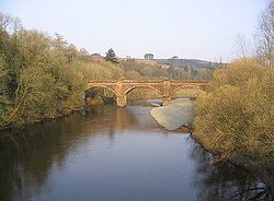
Auldgirth Bridge
| Audgirth Bridge | |||
| Location Map ( geo) | |||
 | |||
| |||
| From: | Dumfries | ||
| To: | Thornhill | ||
| Location | |||
| Auldgirth | |||
| County | |||
| Dumfriesshire | |||
| Highway Authority | |||
| Transport Scotland | |||
| Opening Date | |||
| 1782, 1979 | |||
| On road(s) | |||
| A76 | |||
| Crossings related to the A76 | |||
Auldgirth Bridge formerly carried the A76 across the River Nith just north of Dumfries. It was bypassed by a new bridge in 1979, although rather confusingly, the original bridge was also formerly known as 'New Bridge'.
The old New Bridge
The original Auldgirth Bridge was never completed. Started in 1773, one of the piers failed and the work was abandoned. In 1780, work finally restarted, with a new bridge and new contractor initially demolishing the older work. This is the bridge which still stands today, with three equal stone arches spanning the river, the two piers rising from the riverbed. With an unusually wide roadway for the time, the bridge remained in use until 1979, but the sharp bends at either end to cross the river were an increasing problem.
An interesting feature of the bridge is the pedestrian refuges either side of the roadway. Thick pilasters rise up from the cutwaters to parapet level, offering refuges, however, the unusual part is that small semi circular domed roofs the curve up flush with the inner face of the parapet to provide shelter as well as safety from passing traffic. These refuges are repeated above the abutments, giving a total of 4 on each side. When the bridge was still in use by the A76, there were no pavements, and so these refuges were edged with black and white paintwork to highlight them to passing traffic.
The new New Bridge
The A76 now crosses the Nith a little downstream on a significant skew to avoid the tight bends of the old bridge. This meant 4 spans were used to cross the river, although the easternmost appears to be wider and act as a flood arch. The two western piers sit in the river bed and support the concrete deck with a wide 2-lane road and pavements.
| Auldgirth Bridge | ||||||
| ||||||
|


