Kendal
Jump to navigation
Jump to search
| Kendal | |||
| Location Map ( geo) | |||
 | |||
| |||
| County | |||
| Westmorland | |||
| Highway Authority | |||
| Westmorland and Furness | |||
| Forward Destination on | |||
| A6 • A590 • A591 • A684 • A5284 | |||
| Next Primary Destinations | |||
| Penrith • Lancaster • Windermere • Barrow | |||
| Other Nearby Primary Destinations | |||
| Kirkby Lonsdale • Brough | |||
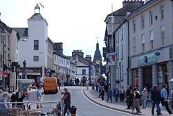
Kendal is a town at the edge of the Lake District National Park, famous for its mint cake and confusing one way system.
Routes
| Route | To | Notes |
| Shap | Old road to Penrith via Shap Summit - cause of many HGV breakdowns | |
| Milnthorpe | Multiplexes with A591, then A590, then non primary | |
| Barrow | Via A6, then A591 | |
| The SOUTH (M6), Lancaster | Via A6 | |
| Windermere | Via A5284. Main tourist route from the south into the Lake District | |
| Windermere | Route from town centre to A591 | |
| The NORTH (M6), Penrith, Sedbergh, Hawes | Non primary after M6 J37. | |
| Tebay | Primary to Brough after M6 J38 | |
| Kirkby Lonsdale | Primary after M6 J36. Main route to here for HGVs is via A6, A591 and A590 instead | |
| Crook | ||
| Oxenholme |
Links
| Kendal | ||
| ||
| ||
|

