Star.pngStar.pngStar grey.pngStar grey.pngStar grey.png

Lindsay's Bridge

From Roader's Digest: The SABRE Wiki
Jump to navigation Jump to search
Lindsay's Bridge
Location Map ( geo)
The Bann in flood (3) - Geograph - 926194.jpg
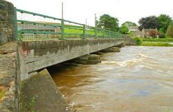
The present bridge with the river in flood, 2008
Cameraicon.png View gallery (2)
Location
Banbridge
County
Down
Highway Authority
DfI Roads
Additional Information
Bridge Type:  Concrete Bridge
On road(s)
C348

Lindsay's Bridge is a concrete bridge carrying the C348 across the Upper Bann near Banbridge.

The older bridge in 1979

The bridge is a concrete construction, built to replace an earlier bridge some time between 1979 and 2008.


Lindsay's Bridge
Related Pictures
View gallery (2)
Lindsay's Bridge, Banbridge (4) - Geograph - 989156.jpgThe Bann in flood (3) - Geograph - 926194.jpg
Crossings of the River Bann
Upper BannNew Bridge • Eight Mile Bridge • Lisnamulligan Bridge • Ballycoshone Bridge • McCombs Bridge • Bannfield Bridge • Roughan Bridge • Ballyroney Bridge • Seafin Bridge • Kate McKay's Bridge • Poland's Bridge • Mulligan's Bridge • Ballievey Bridge • Lisnaree Bridge • Lindsay's Bridge • A1 Bridge • Bann Bridge (Banbridge) • Huntly Bridge • Lawrencetown Bridge • Tullylish Bridge • Gilford Bridge • White Bridge • Dynes Bridge • Bann Bridge (Portadown) • Shillington Bridge • M1 Bridge
Lower BannToome Bridge • New Toome Bridge • Bann Bridge (Portglenone) • Kilrea Bridge • Agivey Bann Bridge • Bann Bridge (Coleraine) • Sandelford Bridge


SABRE - The Society for All British and Irish Road Enthusiasts
Discuss - Digest - Discover - Help