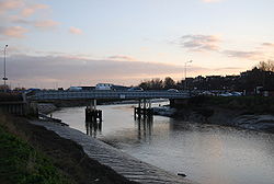
Monk Bretton Bridge
| Monk Bretton Bridge | |||
| Location Map ( geo) | |||
 | |||
| |||
| From: | Rye | ||
| To: | East Guldeford | ||
| Location | |||
| Rye | |||
| County | |||
| Sussex | |||
| Highway Authority | |||
| East Sussex | |||
| On road(s) | |||
| A259 | |||
| Crossings related to the A259 | |||
Monk Bretton Bridge crosses the River Rother on the A259 to the east of Rye town centre. It is the nearest bridge to the sea.
The bridge opened on 25 April 1893 and cost £3,160. It is named after the Baron Monk Bretton, a local peer, and consists of a two-lane road deck over two iron piles sunk into the river. The piles were reinforced with concrete shortly before World War I.
The bridge replaced a ferry in the same location, and ran parallel to the upstream bridge carrying the Marshlink line from Rye to Ashford. The connecting road over the bridge from Rye town centre to East Guldeford was built at the same time. This road became part of the A259 on classification in 1923.
Although the A259 remains a busy trunk road, even more so after the construction of the A2070 which links Hastings and Rye to the M20, the bridge has not been widened, contributing to the numerous traffic problems along the A259 in the area. In October 2007, the bridge was closed for repairs, causing disruption around Rye as the next upstream road, the Royal Military Road is several miles to the north and requires a substantial detour to reach the area immediately to the east of the bridge, with no connecting crossing until Appledore.
| Monk Bretton Bridge | ||
|