Skerton Bridge
Jump to navigation
Jump to search
| Skerton Bridge | |||||||||
| Location Map ( geo) | |||||||||
 | |||||||||
| Location | |||||||||
| Lancaster | |||||||||
| County | |||||||||
| Lancashire | |||||||||
| Highway Authority | |||||||||
| Lancashire | |||||||||
| Opening Date | |||||||||
| 1788 | |||||||||
| Cost | |||||||||
| £14,000 | |||||||||
| Additional Information | |||||||||
| |||||||||
| On road(s) | |||||||||
| A6 • A683 | |||||||||
| Crossings related to the A6 | |||||||||
Town Bridge (Bedford) • Walton Bridge (Preston) • Knightsbridge • Derwent Bridge (Matlock) • Irthlingborough Viaduct • Barrow upon Soar Bridge • Luton Bridges • Great Bowden Bypass Bridge • Milford Bridge (Derbyshire) • Whatstandwell Bridge • Matlock Bridge • Rowsley Bridge • Kirkland Bridge • Garstang Bridge • Mersey Square Bridge • Chapel Bypass Bridge • Greyhound Bridge | |||||||||
| Crossings related to the A683 | |||||||||
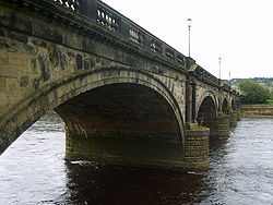
Skerton Bridge carries both the A6 and A683 across the River Lune in central Lancaster. It is the original road bridge across the river, replacing a much older structure to the south in the 18th Century. Since 1972 it has formed part of a gyratory system, effectively a roundabout, with the Greyhound Bridge.
Traffic congestion is frequent on the bridge owing to the sheer number of vehicles crossing it - the Heysham to M6 Link road completion should relieve this situation somewhat.
| Skerton Bridge | ||
| ||
|
