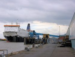
Hull - Zeebrugge ferry
Jump to navigation
Jump to search
| Hull - Zeebrugge ferry | |||
| Location Map ( geo) | |||
 | |||
| The ferry in 2007 | |||
| |||
| From: | Hull | ||
| To: | Zeebrugge | ||
| Distance: | 368.3 km (228.9 miles) | ||
| County | |||
| Yorkshire • Belgium Error: Belgium is not a county | |||
| Current Operator | |||
| P&O | |||
| Toll | |||
| from £154 (Cars) | |||
| On road(s) | |||
| A1033, N31 (Belgium) | |||
| Crossings related to the A1033 | |||
The route was operated by North Sea Ferries (a joint venture between P&O and Nedloyd until 1996, before being subsumed into P&O[1]). In October 2020, P&O began consultation with staff on the closure of the route[2].
Routes
British Side
| Route | To | Notes |
| Leeds, Humber Bridge, City Centre, (M62) | Signed as A63 | |
| Bridington, Withersea, Hedon |
Belgian Side
| Route | To | Notes |
| Zeebrugge, Brugge | ||
| Error: N31 (Belgium) does not exist | ||
Ferries
| Name | IMO | Operator | Dates | Notes |
|---|---|---|---|---|
| Pride of Bruges formerly Norsun |
8503797 | P&O | 2001-date | |
| Pride of York formerly Norsea |
9208617 | P&O | 2001-date | |
| Norland | 7333822 | P&O | 1987-2001 | |
| Norstar | 7360710 | P&O | 1987-2001 |
References
Links
| Hull - Zeebrugge ferry | ||||
| ||||
| ||||
|
