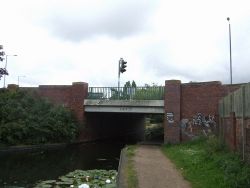
Lane Head Bridge
| Lane Head Bridge | |||||
| Location Map ( geo) | |||||
 | |||||
| Location | |||||
| Willenhall | |||||
| County | |||||
| Staffordshire | |||||
| Highway Authority | |||||
| Walsall | |||||
| Opening Date | |||||
| 1998 | |||||
| Additional Information | |||||
| |||||
| On road(s) | |||||
| A462 | |||||
Lane Head Bridge takes the A462 across the Wyrley and Essington Canal on the northern side of Willenhall, Staffordshire.
The bridge was constructed in 1998 as a replacement to the original 1795 bridge, and is now a simple girder bridge that is much longer than the original bridge and the bridge deck itself has four arms. The original bridge was architecturally very similar to the other original bridges carrying the main roads over the canal on the eastern side of Wolverhampton, such as Wards Bridge or Castle Bridge; but unlike the modern bridge was jammed in between the junctions either side, meaning a much steeper approach.
The presence of this bridge means that the junctions either side with Bentley Lane and Bloxwich Road North are rather awkward, and the whole bridge area is now light-controlled and treated as one junction.
When the canal was constructed, the canal company only provided a bridge here, on the original route between Willenhall and Bloxwich, and not on the original route between Willenhall and Cannock, which was along the obvious route via Haley Street and Ezekiel Lane to the west. Instead, the canal company constructed Straight Road to connect the two routes.
| Lane Head Bridge | ||
|


