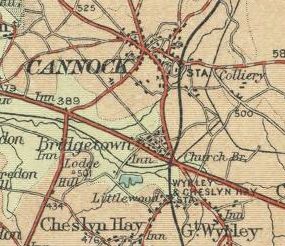
Cannock
| Cannock | |||
| Location Map ( geo) | |||
 | |||
| |||
| County | |||
| Staffordshire | |||
| Highway Authority | |||
| Staffordshire | |||
| Forward Destination on | |||
| M6 Toll, A5, A34, A460 | |||
| Next Primary Destinations | |||
| Brownhills • Rugeley • Telford • Walsall • Wolverhampton | |||
| Other Nearby Primary Destinations | |||
| Lichfield • Stafford | |||
| Other Nearby Destinations | |||
| Wednesfield | |||
| Places related to the A5 | |||
Milton Keynes • Bangor (Caernarfonshire) • Llangollen • Telford • Brownhills • Dunstable • St Albans • Central London • London • Holyhead • Tamworth • Betws-y-Coed • Oswestry • Shrewsbury • Rugby • Hinckley • Kilburn • Lutterworth • Brent Cross • DIRFT • West End • Wellington (Shropshire) | |||
| Places related to the A34 | |||
Stafford • Stratford-upon-Avon • Walsall • Manchester • Birmingham • Winchester • Newbury • Oxford • Stone • Congleton • Newcastle-under-Lyme • Stoke-on-Trent • Solihull • Bicester • Chipping Norton • Wilmslow • Alderley Edge • Abingdon • Salford | |||
| Places related to the A460 | |||
Cannock is a medium-sized town in Staffordshire, to the northeast of Wolverhampton and the north of Walsall. It is traditionally a mining town, and to the north is located Cannock Chase, an area of Outstanding Natural Beauty. Its non-trunk roads are managed by Staffordshire County Council.
History
Cannock proper lies just to the north of the A5 Watling Street, although its urban area has now extended southwards to encompass the A5 within its boundaries. With the exception of Watling Street, it serves as a focus for the road network of the area, with all the major radial routes meeting almost at a single point in the town centre.
In the 1922 Road Lists, the road running through the town between Stafford to the north and Walsall to the southeast was allocated the number A455, whilst that to the southwest towards Wolverhampton was allocated the A460 number. The other main radials were allocated B-class numbers: B5012 running west-east through the town between Penkridge to the west and Lichfield to the east, whilst B5013 was allocated to the road running to Rugeley.
The only revision made to the town's road numbers during the 1935 Road numbering revision was the reallocation of the then-A455 to the more familiar A34.
A new road towards Wolverhampton was opened on 31 July 1964, named Avon Road. Originally part of A460 it has been renumbered A4601. The three-quarter mile bypass left the Wolverhampton Road south west of Longford crossroads and ran parallel to join the main Walsall - Stafford road 100 yards south of the town centre at Mill Street. The cost was £60,000 and included the town's first set of traffic lights at the Walsall - Stafford road and Mill Street junction.
The next changes to the road network in the area came in 1973, with the extension of A460 through to Rugeley over the former route of B5013 and the creation of the A5190 number replacing the section of B5012 to the east towards Lichfield. In the late 1970s, the main shopping street that carried A34 through the town centre, High Green, was pedestrianised, and the misnamed "Ringway", a short bypass for the town centre was constructed immediately to the north.
In the late 1980s, the Cannock Eastern Bypass was constructed, and A460 moved out of the town centre. This change caused two things: firstly, an increase in traffic on A5 through Bridgetown between Longford Island and Churchbridge, due to the new multiplex between A5 and A460. Secondly, the route through the town centre gained the A4601 number, which was completely in the wrong numbering zone - starting at the A5 and heading northwards further into the 5 zone.
The M6 Toll was opened to the south of the town in 2003, and along with it a new section of A460 ran parallel between Wedges Mills Interchange and Churchbridge, meaning that the multiplex with A5 through Bridgtown was removed. It also had the effect of extending A4601 southwards, meaning that it was finally correctly numbered.
Highways Management
The non-trunk roads in Cannock are maintained by Staffordshire County Council. The only Trunk Road maintained by National Highways in the town is the A5, whilst the M6 Toll is managed by Midland Expressway.
Named Junctions
Routes
Several routes run through the Cannock area.
| Route | To | Notes |
| The NORTH WEST, Stafford | ||
| The SOUTH, Burntwood | ||
| Telford | ||
| Brownhills | ||
| Stafford | ||
| Walsall | ||
| Wolverhampton | ||
| Rugeley, Hednesford | ||
| Wolverhampton | former route of A460 | |
| Lichfield | ||
| Pelsall | ||
| Cheslyn Hay, Wolverhampton | ||
| Penkridge | ||
| Chadsmoor, Rugeley | ||
| Walsall | now A34 | |
| Stafford | now A34 |


