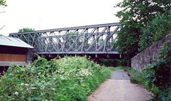
Midland Bridge (Bath)
Jump to navigation
Jump to search
| Midland Bridge (Bath) | |||
| Location Map ( geo) | |||
 | |||
| |||
| From: | Bath, Green Park | ||
| To: | Pines Way, Bath | ||
| County | |||
| Somerset | |||
| Highway Authority | |||
| Bath and North East Somerset | |||
| Additional Information | |||
| |||
| On road(s) | |||
| B3118 | |||
As its name suggests, Midland Bridge was originally built by the Midland Railway Company to improve access to/from their Green Park Terminus Station on the western side of Bath City Centre. The station opened in 1869/70, and the bridge presumably dates from the same time. It is a Truss Bridge carrying the S2 B3118 across.
Sainsbury's
The Former station was renovated in the early 1980s as part of Sainsbury's agreement to get planning permission for a new store. The store (and car park in the old trainshed) are accessed by a bridge a little further downstream which uses the piers and abutments of the old railway bridge, although the deck was replaced.
| Midland Bridge (Bath) | ||||
| ||||
|
