Star.pngStar.pngStar.pngStar grey.pngStar grey.png

Swivel Bridge

From Roader's Digest: The SABRE Wiki
Jump to navigation Jump to search
Brunel's Swivel Bridge
Location Map ( geo)
Brunels rotating bridge at Cumberland Basin, Bristol - Geograph - 5637301.jpg
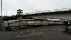
The bridge in 2017
Cameraicon.png View gallery (1)
From:  Ashton Gate
To:  Hotwells
Location
Cumberland Basin
County
Gloucestershire • Somerset
Highway Authority
Bristol
Opening Date
1849
Closure Date
1968
Additional Information
List No:  1202186  (Grade II*)
Bridge Type:  Swing Bridge
Length:  33.7m (110 ft 7 in)
Engineer:  Isambard Kingdom Brunel

Brunel's Swivel Bridge was a crossing of the Cumberland Basin from its opening in 1849,to the construction of the replacement Plimsoll Bridge alongside, which opened in 1965. The bridge is constructed of wrought iron. It was originally located over the south entrance lock, but was shortened and moved to the north entrance lock in 1873[1].


1951 OS 1:25k map showing the bridge


As of 2020, the bridge and mechanism still exist, however, the bridge is not functional, and in an 'open' position, allowing shipping traffic to pass through. The bridge features on English Heritage's Heritage at Risk Register in 2020[2]


References


Swivel Bridge
Related Pictures
View gallery (1)
Brunels rotating bridge at Cumberland Basin, Bristol - Geograph - 5637301.jpg
Other nearby roads
Bristol
A4 • A36 • A37 • A38 • A369 • A370 • A403 • A407 (Bristol) • A420 • A430 (Chippenham - Bristol) • A431 • A432 • A3024 (Bristol) • A3029 • A3034 (Bristol) • A4017 • A4018 • A4032 • A4044 • A4162 • A4174 • A4175 • A4176 • A4320 • B3119 • B3120 • B3121 (Bristol) • B3122 • B3123 (Bristol) • B3124 • B3125 • B3126 • B3129 • B4045 (Keynsham) • B4046 • B4047 (Gloucestershire) • B4048 • B4049 • B4050 • B4051 • B4052 • B4053 • B4053 (Colston Street, Bristol) • B4054 • B4055 • B4056 • B4057 • B4058 • B4465 • B4466 • B4467 • B4468 • B4469 • E30 • E105 (London - Fishguard) • E116 (Old System) • EuroVelo 1 • EuroVelo 2 • Longest Lane • M4 • M5 • M32 • M49 • NCN4 • NCN41 • Outer Circuit Road • South Bristol Spur • T9 (Britain) • T16 (Britain)
Crossings of the River Avon (Bristol & Bath)
AvonJoyces Pool Bridge • St John's Bridge • Malmesbury Bypass Bridge • Cow Bridge • M4 Viaduct • Christian Malford Bridge • Chippenham Bypass Bridge • Bath Road Bridge • Challymead Bridge • Staverton Bridge • Town Bridge (Bradford-on-Avon) • Stokeford Bridge • Bathampton Bridge • Batheaston Bypass Bridge • Cleveland Bridge • Pulteney Bridge • North Parade Bridge • Churchill (Southgate) Bridge • Midland Bridge • Victoria Bridge • Windsor Bridge • Destructor Bridge • Newbridge • Avon Bridge (Keynsham) • A4174 Bridge • Avon Bridge (Bristol) • Bath Bridge • Bedminster Bridge • Avon Bridge (Cumberland Basin) • Clifton Suspension Bridge • Avonmouth Bridge
Floating HarbourSwivel Bridge • Plimsoll Bridge


SABRE - The Society for All British and Irish Road Enthusiasts
Discuss - Digest - Discover - Help