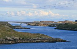
Scalpay Bridge
| Scalpay Bridge Drochaid Scalpaigh | |||
| Location Map ( geo) | |||
 | |||
| |||
| From: | Harris | ||
| To: | Scalpay | ||
| County | |||
| Inverness-shire | |||
| Highway Authority | |||
| Comhairle nan Eilean Siar | |||
| Opening Date | |||
| 1997 | |||
| On road(s) | |||
| C78 | |||
Lying in the entrance to East Loch Tarbert just off the Isle of Harris, Scalpay is a small but populous island. Despite the proximity of the island to Harris, it was only in 1997 that the Scalpay Bridge was opened, after a surprisingly long gestation period, with the first reports instigated in 1986. However, the construction was comparatively swift, running from April 96 to December 97, although advance works on the access roads started almost a year earlier.
The bridge itself is a pre-fabricated box girder structure spanning 300m in total, the central span being 170m. This span is supported by two inclined legs, with their footings on the shore on either side of the Kyles of Scalpay. It can be seen in the distance from the Uig-Harris Ferry as it enters/leaves the ferry port at Tarbert. Whilst some may think it an optical illusion, the bridge really does rise up from Harris to Scalpay, although the approach roads do the opposite, dropping on Harris to meet the bridge and then dropping again once on Scalpay.
The bridge has a single running lane with passing places, and carries vehicular traffic, pedestrians, and a water supply.
History
The Ferry
Before the bridge, Scalpay was connected to Harris via a ferry service, which crossed the Kyles to the east of the new bridge. The old ferry slips can still be seen. A car ferry service only appears to have started in 1956, with the service always having been provided by Caledonian MacBrayne (and it's predecessor). Prior to 1977 the vessels used were exclusively turntable ferries, but after that date CalMacs small bow loaders were implemented on the crossing, forcing traffic to reverse on or off, perhaps a backward step from the older ferries.
| Name | IMO | Operator | Dates | Notes |
|---|---|---|---|---|
| Rhum | 7319589 | Caledonian MacBrayne | 1997 | 6 Cars |
| Canna | 7340423 | Caledonian MacBrayne | 1990-97 | 6 Cars |
| Kilbrannan | 7217872 | Caledonian MacBrayne | 1977-90 | 5 Cars |
| Morvern | 7235501 | Caledonian MacBrayne | 1977 | 5 Cars |
| Glen Mallie | David MacBrayne | 1971-75 (Relief) | 5 Cars | |
| Scalpay | David MacBrayne | 1971-77 | 6 Cars | |
| Scalpay | David MacBrayne | 1965-71 | 4 Cars |
Why a Bridge?
If you have read some of the other pages about crossings in the Western Isles, you will be forgiven for wondering why Scalpay was linked to Harris with a bridge, rather than the more normal causeway. The simple answer is that the Kyles of Scalpay is a deep, steep sided channel, with rapid tidal flows. Constructing a causeway across would be virtually impossible.
Cost
The bridge was built at a cost of £6.4m (with 65% funding from the European Union through the Objective One programme).
Links
Comhairle nan Eilean Siar


