Star.pngStar grey.pngStar grey.pngStar grey.pngStar grey.png

Stranraer - Douglas ferry

From Roader's Digest: The SABRE Wiki
Jump to navigation Jump to search
Stranraer - Douglas ferry
Location Map ( geo)
Isle of Man ferry at Stranraer - Geograph - 565784.jpg
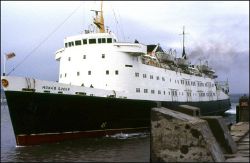
Mona's Queen at Stranraer in 1987
Cameraicon.png View gallery (2)
From:  Stranraer
To:  Douglas
Distance:  162.9 km (101.2 miles)
Location
Irish Sea
County
Wigtownshire • Isle of Man
Crossings related to the A75
Crossings related to the A77
Crossings related to the A8 (Isle of Man)

In the 1980s, there was a short-lived route, run by Isle of Man Steam Packet Company, between Stranraer and Douglas, but this has ceased sailings.


Ferries

Name IMO Operator Dates Notes
Mona's Queen 7127493 Isle of Man Steam Packet Company


Stranraer - Douglas ferry
Junctions
Places
Related Pictures
View gallery (2)
Sea terminal (C) Andrew Abbott - Geograph - 3133794.jpgIsle of Man ferry at Stranraer - Geograph - 565784.jpg
Crossings of the Irish Sea
England/Scotland/Wales Irish SeaBallycastle to Cambpeltown (P) • Troon to Larne • Cairnryan to Belfast • Cairnyran to Larne • Stranraer to Larne • Stranraer to Belfast • Birkenhead to Belfast • Birkenhead to Dublin • Heysham to Warrenpoint • Heysham to Dublin • Liverpool to Dublin • Liverpool to Dun Laoghaire • Mostyn to Dublin • Holyhead to Dublin • Holyhead to Belfast • Holyhead to Dun Laoghaire • Fishguard to Rosslare • Pembroke to Rosslare • Swansea to Cork
Isle of Man FerriesStranraer to Douglas • Heysham to Douglas • Liverpool to Douglas • Birkenhead to Douglas • Belfast to Douglas • Dublin to Douglas
Other AreasIrish Sea • Inner Hebrides • Western Isles • Shetland • Orkney • North Sea • English Channel • Solent • Inland Crossings • Other Island Crossings

SABRE - The Society for All British and Irish Road Enthusiasts
Discuss - Digest - Discover - Help