Swing Bridge (Tyne)
Jump to navigation
Jump to search
| Swing Bridge | |||||||||||
| Location Map ( geo) | |||||||||||
 | |||||||||||
| From: | Gateshead | ||||||||||
| To: | Newcastle | ||||||||||
| County | |||||||||||
| Durham • Northumberland | |||||||||||
| Highway Authority | |||||||||||
| Newcastle upon Tyne • Gateshead | |||||||||||
| Opening Date | |||||||||||
| 1876 | |||||||||||
| Cost | |||||||||||
| £240,000 | |||||||||||
| Additional Information | |||||||||||
| |||||||||||
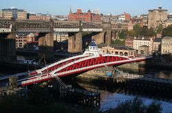
The Swing Bridge linking Newcastle upon Tyne and Gateshead is situated on the site of the oldest crossing of the River Tyne, immediately upstream from the better known Tyne Bridge.
There has been a crossing here since Roman times, when it was known as Pons Aelius. Since the classification of roads predates the opening of the Tyne Bridge, the Swing Bridge was originally a major road, and carried the original route of the A184, though it continued to be an important crossing for some years afterwards.
Today, however, the bridge is unclassified.
| Swing Bridge (Tyne) | ||||||
| ||||||
|


