Tyne Bridge
| Tyne Bridge | |||||||||||
| Location Map ( geo) | |||||||||||
 | |||||||||||
| From: | Gateshead | ||||||||||
| To: | Newcastle upon Tyne | ||||||||||
| County | |||||||||||
| Durham • Northumberland | |||||||||||
| Highway Authority | |||||||||||
| Newcastle upon Tyne • Gateshead | |||||||||||
| Opening Date | |||||||||||
| 10 October 1928 | |||||||||||
| Cost | |||||||||||
| £1.2m | |||||||||||
| Additional Information | |||||||||||
| |||||||||||
| On road(s) | |||||||||||
| A167 | |||||||||||
| Crossings related to the A167 | |||||||||||
The iconic Tyne Bridge opened on 10 October 1928, linking the centres of Newcastle upon Tyne and Gateshead at a high level, approximately 25m above the River Tyne. Construction started in 1925 to a design by Mott, Hay and Anderson, with the contractors being Dorman Long. These same contractors later went on to design the Sydney Harbour Bridge in Australia. Spanning 161.8m, the Tyne Bridge cost £1.2m to build.
The road was originally S2 and had tram tracks running along it. The tram tracks have since gone and the road is marked out as an S4 and feeds directly into the A167(M) Newcastle Central Motorway.
The bridge originally opened as the A1, but then when the A1 was routed through the Tyne Tunnel in the early 1980s it became the A6127. Then when the A1 moved again to its present location it look on the A167 number.
The Structure
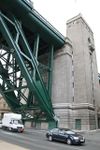
The Tyne Bridge is a Suspension Bridge of sorts, with the road deck suspended from the huge steel truss-arches that span the river. At each end these arches taper to pin-joints at the base of the massive towers that carry the deck and counteract the forces exerted by the arches. The road deck sits between the arches, but the pedestrian walkways are cantilevered out to the sides.
At the Newcastle end, three further spans supported by steel piers either side of Queen Street carry the road deck to higher ground, while on the Gateshead side only two, shorter, spans are used with piers between Hillgate and Church Street. These subsidary parts of the bridge are more normal girder bridges, as the spans are far shorter than the central one.
Under the Bridge
With the steeply sloping banks of the Tyne, and the need to allow tall ships further upstream, the Tyne Bridge deck stands up to 50 feet above ground level on the river banks. In Newcastle this means it crosses over buildings, in Gateshead, where the riverbank gains height more quickly, it is just old industrial land. On both sides, however, there is a severe guano problem from the gulls nesting on the bridge.
Queen Street & Lombard Street
At the northern end, the Tyne Bridge crosses over four-storey buildings in the city's Queen Street area. Due to the height of the bridge deck, however, not all of the buildings beneath the bridge were demolished. A small corner of a terrace was lost to allow for the piers supporting the approach, but the remainder simply had their pitched roofs removed and replaced with flat roofs. This may seem like an odd solution, but it has helped to maintain the cityscape, and limits the impact of the bridge far overhead.
| Tyne Bridge | ||||||
| ||||||
|


