Star.pngStar.pngStar grey.pngStar grey.pngStar grey.png

Keele services

From Roader's Digest: The SABRE Wiki
Jump to navigation Jump to search
Keele services
Location Map ( geo)
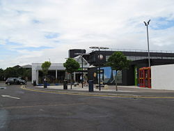
Keele Services - northbound side - Geograph - 905206.jpg
Cameraicon.png View gallery (13)
Location
Keele
County
Staffordshire
Opening Date
1963
Current Operator
Welcome Break
On road(s)
M6
Globe.png
For detailed information about this topic, see Motorway Services Online, Motorway Services Info and MSA Trivia


Keele Services on the 1969 OS Quarter Inch map.

Keele services is located on the M6 between Junctions 15 and 16 to the southwest of Newcastle-under-Lyme.

The services opened in 1963, and was originally operated by Forte. It is named after the nearby village of Keele, and is approximately one mile from Keele University.

It is unusual in having signage within the central reservation when heading southbound along M6.

The local access route connects to the Class III road C119 Three Mile Lane; and was historically very busy as it was the nearest access from the motorway network to Keele University - however this is no longer possible due to barriers.


Keele services
Related Pictures
View gallery (13)
Keele Motorway Service Station - Geograph - 1259265.jpgKeele Services Northbound - Geograph - 1619727.jpgM6 Keele Services - Geograph - 857142.jpgMain Buildings, Keele Services, M6 Northbound - Geograph - 1230765.jpg1000044391.jpg
Services on the M6
ExtantRugby • Corley • Hilton Park • Stafford (South) • Stafford (North) • Keele • Sandbach • Knutsford • Lymm • Charnock Richard • Lancaster (Forton) • Carnforth • Burton-in-Kendal • Killington Lake • J38 truckstop • Tebay • Southwaite • Todhills
UnsignedCrewe • Tickled Trout • Golden Fleece
ProposedSwinford • Harborough Magna (Stretton-under-Fosse) • Perry Barr • Essington • Doxey • Woolston • Winwick • Haydock Park • Melkinthorpe
Services in the West Midlands region
ExistingCorley • Crewe • Frankley • Hilton Park • Hopwood Park • Keele • Norton Canes • Ross Spur • Stafford (North) • Stafford (South) • Strensham • Tamworth • Telford • Warwick
UnbuiltAustrey • Blackfirs • Catherine-de-Barnes • Defford • Doxey • Droitwich • Dunton • Essington • Gaydon • Harborough Magna (Stretton-under-Fosse) • Lizard Hill • Longbridge • Moreton Valence • Perry Barr • Pershore • Rugby • Staverton

SABRE - The Society for All British and Irish Road Enthusiasts
Discuss - Digest - Discover - Help