Star.pngStar grey.pngStar grey.pngStar grey.pngStar grey.png

Oakmere Crossroads

From Roader's Digest: The SABRE Wiki
Jump to navigation Jump to search
Oakmere Crossroads
Location Map ( geo)
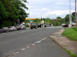
Crossroad - Chester Road and A49 near Tarporley - Geograph - 173218.jpg
Cameraicon.png View gallery (2)
Location
Sandiway
County
Cheshire
Highway Authority
Cheshire West and Chester
Junction Type
Signalised Cross Roads
Roads Joined
A49, A556
Junctions related to the A556

Oakmere Crossroads is the of the A49, and the A556 near Sandiway in Cheshire. The area is mainly agricultural, and has a number of large sand quarries nearby.

The A49 runs from Ross-on-Wye to Bamber Bridge, near Preston

The A556 runs from Delamere to Bowdon.


Routes

Route To Notes

A49

Warrington, Cuddington 1, Weaverham 3, (M56)

A49

Whitchurch, Nantwich (A51), Oulton Park 4, Tarporley 5

A556

(M6), Manchester, Northwich 5, (M56)

A556

N. WALES, Chester (A51)


Oakmere Crossroads
Related Pictures
View gallery (2)
Crossroad - Chester Road and A49 near Tarporley - Geograph - 173218.jpg20180402-1204 - Oakmere Crossroads.jpg
Junctions on the A49
Wilton Roundabout • Hope-under-Dinmore Junction • Woofferton Crossroads • Belmont Roundabout • Edgar Street Roundabout • Bayston Hill Roundabout • Preston Island • Battlefield Roundabout • Prees Heath • Ridley Junctions • Four Lane Ends • Sandybrow Crossroads • Oakmere Crossroads • Weaverham Roundabout • Dones Green Crossroads • Stretton • Owens Corner • Brian Bevan Island • Bridge Foot • St Mary's Green • Cockhedge Green • Longford Roundabout • Stump Cross • Winwick Park Roundabout • Winwick • Haydock Island • Marus Bridge Roundabout • Saddle Junction • Boar's Head • Bamber Bridge Junction


SABRE - The Society for All British and Irish Road Enthusiasts
Discuss - Digest - Discover - Help