Chester
| Chester | |||
| Location Map ( geo) | |||
 | |||
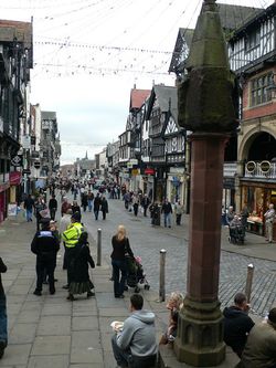
| The centre of Chester. Several two digit A roads met at or near here. | |||
| |||
| County | |||
| Cheshire | |||
| Highway Authority | |||
| Cheshire West and Chester | |||
| Forward Destination on | |||
| M53, M56, A41, A51, A54, A55, A483, A494 | |||
| Next Primary Destinations | |||
| Ellesmere Port • Runcorn • Northwich • Nantwich • Queensferry • Conwy • Mold • Whitchurch | |||
| Places related to the M53 | |||
| Places related to the M56 | |||
| Places related to the A41 | |||
Wolverhampton • Solihull • Birmingham • Watford • Aylesbury • Hemel Hempstead • Central London • London • Brent Cross • West End • Warwick • West Bromwich • Whitchurch • Birkenhead • Tring • Bicester • Ellesmere Port • Banbury • Bilston • Wednesbury | |||
| Places related to the A51 | |||
| Places related to the A55 | |||
Bangor (Caernarfonshire) • Queensferry • Conwy • Holyhead • Rhyl • Flint • Prestatyn • Abergele • St Asaph | |||
Chester is a city on the River Dee close to North Wales and The Wirral, and acts as a major commercial centre for both those areas. There have been transport links to the city since Roman times, and many long distance routes terminate here, including the A51, A54, A55, A56, M53 and M56.
There have been numerous projects to bypass the city. Probably the most important one lay to the north, which started in the 1930s with the construction of the A5117 to connect the A56 to the A550 (and hence the A55), and continued with the arrival of the M56 and subsequent projects to improve and grade separate the route, which continue today. The current bottleneck is just inside the border with Wales, where the road narrows from 4 to 2 lanes heading westbound.
The other main bypass has been to the south and east, forming an extension of the A55 up to meet the M53.
History
Chester Eastern Bypass
The 2 mile dual carriageway from Christleton to Plas Newton Lane, Newton was opened in July 1941. Christleton to A56 Hoole Road was new build. A56 Hoole Road to Plas Newton Lane was a widening of B5131. Use of the existing B5131 completed the bypass through Upton to Moston. Work had commenced on 31 October 1938. It had been virtually completed by November 1940 but lack of available manpower to make the junctions safe delayed the opening.
Chester Inner Ring Road
Stage 1 - the Southern section from A483 Grosvenor Roundabout to A51 The Bars (0.6 mile) had been completed in 1965. This was an upgrade of existing streets, but still single carriageway. Cost was £227,000.
Stage 2 - St Martin's Way and Nicholas Street. The Western section from A483 Grosvenor Roundabout to A5116 Fountains Roundabout was opened on 22 April 1966 by Barbara Castle, Minister of Transport. 0.85 mile dual carriageway. It contraversially cut through the City Walls, with a replacement concrete arch on St Martin's Way. The northern section was an elevated viaduct, 900 feet in length. Cost was £1.4 million.
Stage 3 - St Oswalds Way. The North-eastern section from A5116 Fountains Roundabout to A51 The Bars and the A56 link on Hoole Way to Hoole Way Roundabout was opened on 31 October 1971. They were dual carriageways. Some work remained to be done at the time, which would involve temporary lane closures. This completed the Ring Road which had cost £3 million in total.
Chester Western Bypass
Phase 1: Countess Way from Liverpool Road (A5116) to Parkgate Road (A540) was opened on 2 October 1989 by Jim Humphries, County Council Chairman. Constructed by Redrow Construction.
Phase 2: Deva Link (north) from Parkgate Road (A540) to Saughall Road was opened on 27 August 1993 by Peter Walker, County Council Chairman. Cost £6.5 million.
Phase 3: Deva Link (south) from Saughall Road to Sealand Road (A548) was opened on 15 September 1993 per the Land Compensation Act notice. It was opened by David Lloyd Griffiths, Environment Services Committee Vice-chairman, and Margaret Byatt, Mayor. Phase 3 was constructed by the developer of Chester Retail Park and this completed the Bypass.
See A5480.
Chester Second Eastern Bypass (North Wales Expressway)
The A55 dual carriageway from M53 Hoole Island Junction to Boughton Heath Junction (for the Chester Southern Bypass) was opened on 27 June 1991 per the Land Compensation Act notice.
Routes
| Route | To | Notes |
| Liverpool, Ellesmere Port | ||
| Runcorn, Warrington, Manchester, Airport | ||
| NORTH WALES, Holyhead, Queensferry | ||
| Birkenhead | ||
| Whitchurch | ||
| Nantwich | ||
| Congleton | via A51 | |
| Northwich | via A51, A54 | |
| Wrexham | ||
| Mold | ||
| Neston | ||
| Queensferry, Flint | ||
| Helsby | ||
| Broughton | Former A55. |


