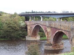
Drygrange Bridge
| Drygrange Bridge | |||
| Location Map ( geo) | |||
 | |||
| |||
| Location | |||
| Leaderfoot | |||
| County | |||
| Roxburghshire | |||
| Highway Authority | |||
| Transport Scotland | |||
| Opening Date | |||
| 1780, 1974 | |||
| Additional Information | |||
| |||
| On road(s) | |||
| A68 | |||
| Crossings related to the A68 | |||
The old Drygrange Bridge crosses the River Tweed at Leaderfoot, but is no longer open to traffic. It was built in 1780 and consists of 3 main arches with a smaller flood arch under the south approach. The centre of the 3 arches is the largest, and they are separated by triangular cutwaters rising in front of the piers to form refuges. The larger central arch originally created a hump-back profile to the bridge, as can still be seen by the string course below the parapets. However, at some point in history the deck and parapets were raised at either end to create a near level roadway. The bridge was used by the A68 up until 1974 when the new bridge was opened, and is now restricted to a footbridge, which meets the B6360 at the northern end.
Leaderfoot Bridge
Standing almost above the old bridge on the north bank of the Tweed, Leaderfoot Bridge is a modern concrete and steel structure which crosses the river slightly downstream. Box Girders support the concrete deck, and are themselves supported by paired concrete piers set on either bank of the river, with additional piers further from the river. The bridge stands higher than the old crossing, and carries a full modern S2 roadway with pavements.
It was completed in 1974, along with the 1.43 mile diversion, per the 1974 Scottish Development Department Report.


