Linton Interchange
Jump to navigation
Jump to search
| Linton Interchange | |||
| Location Map ( geo) | |||
 | |||
| |||
| Location | |||
| Linton | |||
| County | |||
| Herefordshire | |||
| Highway Authority | |||
| National Highways | |||
| Junction Type | |||
| LILO | |||
| Roads Joined | |||
| M50, B4221 | |||
| Junctions related to the B4221 | |||
Linton Interchange, the M50's junction 3, is arguably the lowest-standard motorway junction in England. It is a simple LILO interchange with very little in the way of acceleration and deceleration lanes. As it opened in the early 1960s it features many outdated design features and has more in common with all-purpose roads of the same era than of motorways.
One theory suggests this was a temporary junction whilst the adjoining B-road was upgraded in expectation of a re-routing of the nearby A40.
Strip Maps
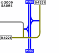
The current layout of the interchange.

Grid Reference
Links
Roads.org.uk
| Linton Interchange | ||||||||||
| ||||||||||
|

_-_Coppermine_-_8382.jpg)
_-_Coppermine_-_8373.jpg)
_-_Coppermine_-_8377.jpg)
_-_Coppermine_-_8359.jpg)