Littlebrook Interchange
| Littlebrook Interchange | |||
| Location Map ( geo) | |||
 | |||
| The A206 overbridge at Littlebrook Interchange | |||
| |||
| Location | |||
| Littlebrook | |||
| County | |||
| Kent | |||
| Highway Authority | |||
| National Highways | |||
| Junction Type | |||
| Dumbbell-Parlo Hybrid | |||
| Roads Joined | |||
| A282, A206, B2228 | |||
| Junctions related to the A206 | |||
Littlebrook Interchange was first built in 1988 as a unclassified junction for the eastern parts of Dartford & for the opening of Crossways. It was S2 at this point. In 1993, the A206 was extended to this junction. It was also around this time that the central part of the junction became D2. In 1996, the A206 was extended towards Crossways. In 1999, Bluewater opened and the A206 was extended towards Bluewater. It was also at this time that the B2228 was classified. Lastly due to the large amounts of traffic using this junction, in the mid 00's traffic lights were installed. This is a very busy junction for the kind of traffic that uses it. It also used via the A206 & the B255 to get to Bluewater. It is junction 1a of the A282 (M25 in disguise).
Routes
| Route | To | Notes |
| The NORTH, Dartford Toll Crossing, M25 (M1, M11), Stansted | ||
| The SOUTH, Gatwick, Channel Tunnel, Dover M25 (M20, M23) | ||
| Crayford, Erith | ||
| Bluewater, Greenhithe | ||
| Stone, Dartford |
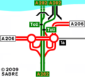
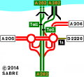
Strip Maps
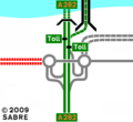
Littlebrook Interchange as it upon opening in 1988.
Littlebrook Interchange as it was in 1991.
Littlebrook Interchange as it was in 1992.
Littlebrook Interchange as it was in 1993.
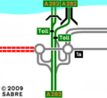
Littlebrook Interchange as it was in 1996.
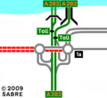
Littlebrook Interchange as it was in 1999.
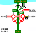
Littlebrook Interchange as it was in 2011.
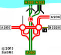
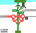
The current layout of the interchange.


Links
Grid References

