Princes Road Interchange
| Princes Road Interchange | |||
| Location Map ( geo) | |||
 | |||
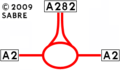
| Northbound Slip Road | |||
| |||
| Location | |||
| Dartford | |||
| County | |||
| Kent | |||
| Highway Authority | |||
| National Highways | |||
| Junction Type | |||
| Limited Roundabout | |||
| Roads Joined | |||
| A282, A225, A296 | |||
| Junctions related to the A225 | |||
| Junctions related to the A296 | |||
Princes Road Interchange, junction 1B of the A282, was first built in 1963 when the A282 opened for the first Dartford Tunnel. It was much more important then than now as it was the junction for the A2. In 1972, the Second Dartford By-Pass opened and the A282 was extended to the Darenth Interchange. This moved the A2 south and the old road was renumbered A225 & A296. During the late 1980's works for the Dartford Bridge, this junction was made limited access. That meant traffic from the South had to use J2 of the M25 to get to this junction. In 2006, Fastrack open and that added to the fun & games when this junction get jammed (and that is basically once a week). In 2014, a new McDonalds opened near the junction so even more traffic now uses the junction.
Routes
| Route | To | Notes |
| Channel Tunnel, Gatwick Airport (M23) | All via M25 | |
| The NORTH, Dartford Crossing, Stansted Airport, (M11, M1) | ||
| Crayford, Dartford | ||
| Greenhithe, Bluewater |
Strip Maps
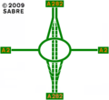
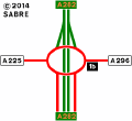
Princes Interchange as it was in 1963 as a non-GSJ Junction.
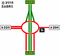
Princes Interchange as it was in 1970 before the opening of the 2nd Dartford By-Pass.
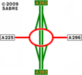
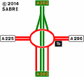
Princes Interchange as it was in 1972.
Princes Interchange as it was in 1988.
Princes Interchange as it was in 1991.
Princes Interchange as it was in 2004.
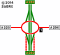
The current layout of the interchange.


Links
Grid References
