C37 (Inverclyde)
| C37 | ||||
| Location Map ( geo) | ||||
 | ||||
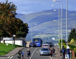
| At Bardrainney, near the west end of the road | ||||
| ||||
| From: | Port Glasgow (NS334733) | |||
| To: | Auchenbothie (NS345707) | |||
| Distance: | 2.1 miles (3.4 km) | |||
| Meets: | C77, C17, A761 | |||
| Highway Authorities | ||||
| Traditional Counties | ||||
| Route outline (key) | ||||
| ||||
For other roads numbered C37, see C37.
The C37 starts on the C77, Dubbs Road in Port Glasgow. It heads south, curving to the south east and follows the former St Enoch to Princes Pier railway line, now a busy cycle track, for the entire route to the A761 at Auchenbothie near Kilmacolm.
Route
Port Glasgow Suburbs
The road climbs climbs steadily from the shops at the junction with Dubbs Road, passing between the housing schemes of Bardrainney, Mid Auchinleck and Slaemuir on the way to the Port Glasgow boundary.
Hamilton Bardrainney Church on the left and later St Francis church on the right are the only non-residential buildings on the road at this suburban stretch of the road.
Countryside to Kilmacolm
From the Port Glasgow boundary, the road narrows considerably for the remainder of its length. It rises and falls and twists and turns as it runs more or less parallel to the former St Enoch to Princes Pier railway, this part of which closed in 1965. The line,on the south side of the road, is now a busy cycle path, part of the National Cycle Network Route 75. Craigmarloch Wood can be seen beyond the fields on the north side of the road.
The C17 branches off to the right, immediately passing under "Penny's Arch" which carries the old railway line.
Junction with the A761
The junction is reached shortly after passing the former railway cottages at the junction with Netherton Road on the right side. The junction surrounds a grass triangle, which is formed by the T junction and a lay-by/bus stop which is reached only from the west bound A761.


