C58 (Inverclyde)
Jump to navigation
Jump to search
| C58 | ||||
| Location Map ( geo) | ||||
 | ||||
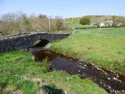
| The bridge carries the C58 over Green Water. The B788 can be seen in the background. | ||||
| ||||
| From: | Gateside (NS328692) | |||
| To: | Pomillan (NS346670) | |||
| Distance: | 1.8 miles (2.9 km) | |||
| Meets: | B788, B786 | |||
| Highway Authorities | ||||
| Traditional Counties | ||||
| Route outline (key) | ||||
| ||||
This article is about the Class III road numbered C58 maintained by Inverclyde Council.
For other roads numbered C58, see C58.
For other roads numbered C58, see C58.
The C58 forms a link between the B788 at Gateside and the B786 at Pomillan Bridge to the south west of Kilmacolm.
Route
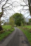
The road starts pretty much as it continues, narrow and twisting between sheep and cattle pastures and dotted with farms and farm related buildings along the way.
An unclassified road drops steeply back to the B788, past the ruins of Duchal Castle. Further on, two other unclassified roads link to the B786, coming out north and south of the C58.
A few additional unclassified roads serve the hill farms to the south.
South Newton Girl Guide camp is located in a former farmhouse at a staggered junction near the east end of the road.


