C83 (Inverclyde)
| C83 | ||||
| Location Map ( geo) | ||||
 | ||||
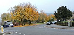
| Looking across Carwood Street to the north end of East Crawford Street | ||||
| ||||
| From: | Carwood Street (NS292754) | |||
| To: | Strone Crescent / Bridgend Road (NS287752) | |||
| Via: | East Crawford Street, Bawhirley Road | |||
| Distance: | 0.8 miles (1.3 km) | |||
| Meets: | C82 | |||
| Highway Authorities | ||||
| Traditional Counties | ||||
| Route outline (key) | ||||
| ||||
For other roads numbered C83, see C83.
The route of Inverclyde Council's C83 is not clear from the council lists, which identify it as being East Crawford Street in its entirity and also Bawhirley Road from East Crawford Street up to Strone Crescent, all on the eastern side of Greenock. These two roads form a T shape, and there is no suggestion of any other roads forming part of the route.
Route
East Crawford Street
East Crawford Street begins at the top of the C82 Ratho Street at Carwood Street in the heart of Greenock's east end. Victoria Bowling Club is on the right at this junction and a community centre stands in landscaped grounds on the left.
Bawhirley Road, most of which also forms the C83, is crossed after around 110m. After a further 110m, a long row of brick built semi-detached cottages, more reminiscent of Northern English towns than the industrial heartland of the west of Scotland, stands on the right.
Opposite the cottages stands Kings Oak Primary school at the south end of the street where it ends at the junction with Bridgend Road at Grosvenor Road.
Bawhirley Road
The most striking feature of Bawhirley Road west of East Crawford Street is its gradient; it climbs steeply for most of its length towards Strone Crescent.
The road is mostly residential, ranging from sandstone tenements at the bottom to a mix of semi-detached council houses and a range of cottages and detached villas nearer the top of the hill. Some offices in a former library building and a church (demolished 2022) stand on the north side of the road.
National Cycle Network Route 75 runs along a short length of the road between Galt Street on the south side and Grant Street on the north side.
| C83 (Inverclyde) | |||||||
| |||||||
| |||||||
|


