C36 (Inverclyde)
| C36 | ||||
| Location Map ( geo) | ||||
 | ||||
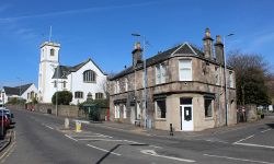
| The road starts at the A761 at Kilmacolm Cross, to the right of the former Post Office | ||||
| ||||
| From: | Kilmacolm (NS357699) | |||
| To: | Council Boundary (NS357713) | |||
| Via: | Finlaystone Road | |||
| Distance: | 0.9 miles (1.4 km) | |||
| Meets: | A761, C18 | |||
| Highway Authorities | ||||
| Traditional Counties | ||||
| Route outline (key) | ||||
| ||||
For other roads numbered C36, see C36.
The C36 starts on the A761 in the centre of Kilmacolm and runs north along the High Street and Finlaystone Road to reach the council boundary just outside the small town.
Route
High Street
Although not the main shopping street in the village, High Street does have some shops and businesses in the area between The Cross and West Glen Road. This stretch of the road is also where the oldest buildings can be seen, most prominent of which is the Old Kirk which dates back to 1836.
Climbing the hill away from The Cross, a mix of old and new residential buildings is passed on both sides of the road until the C18 West Glen Road is reached. From this point onwards, the road is entirely residential.
Finlaystone Road (urban)
The road continues to climb away from the centre of the village. The east side of the road is mostly early 20th Century council built houses, while the west side is mostly detached and semi-detached bungalows and houses as far as the old house at Water Yetts. From this point until the edge of the village most of the houses are council built.
Finlaystone Road (rural)
The rural section of the road begins where the drive to Oldhall branches off to the east, right at the edge of the village. The now single track road continues to climb as it gently bends its way to Migdale at the top of the hill where a couple of houses sit at the roadside amongst the otherwise pastural scene.
The C36 ends at the junction with the lane to Knockmountain, which branches off to the east.


