C79 (Inverclyde)
| C79 | ||||
| Location Map ( geo) | ||||
 | ||||
| Regent Street section of the C79 | ||||
| ||||
| From: | Inverkip Street (NS271761) | |||
| To: | Baker Street (NS282757) | |||
| Via: | Roxburgh Street, Regent Street | |||
| Distance: | 0.8 miles (1.3 km) | |||
| Meets: | A78, B788 | |||
| Highway Authorities | ||||
| Traditional Counties | ||||
| Route outline (key) | ||||
| ||||
For other roads numbered C79, see C79.
The C79 starts on the A78, Inverkip Street in the middle of Greenock and heads east along Roxburgh Street. It then kinks left onto Regent Street which takes it through to the B788, Baker Street.
Route
Roxburgh Street
The road 'starts' at the A78 at Greenock West railway station, but is one way only for the westernmost 150m from Bruce Street. The west bound lane connects directly to the A78 Inverkip Street, but there is no direct eastbound connection from the A78 at this point. East bound traffic from the A78 must take a 1Km detour on Inverkip Street, East Shaw Street and Sir Michael Street to double back on Roxburgh Street and reach the taxi rank at the west end of the road. This situation was remedied in April 2021, at which time a short one way section of Bruce Street was reversed, resulting in a much shorter journey for east bound traffic wishing to access the west end of Roxburgh Street.
The junction at the West Station was 'temporarily' remodelled and one way restrictions introduced on surrounding streets for around ten years in the early 2000s while a solution to the weak bridge over the tracks at the station was agreed and implemented. At the end of this period, some of the temporary restrictions were made permanent and some new ones were introduced.
The street begins to climb from around the the junction with Duncan Street to well beyond the junction with Regent Street.
Greenock Health Centre (address is on Duncan Street) was a notable building on the road until it was demolished in 2022. Other noteable buildings are the former Cooperative Halls and the former sugar refinery warehouse at Bearhope Street.
Regent Street
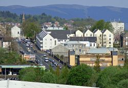
The west end of the street is mostly open and residential until the junction with Trafalgar Street, at which point it becomes slightly more enclosed and commercial in nature. The slope levels out at the lower part of Mearns Street and continues fairly level as it passes Bank Street and the historic Well Park, with its fine row of sandstone tenements with shops opposite.
Passing Lynedoch Street, the road becomes residential on both sides again as it runs down the hill towards Baker Street, past brownfield sites on both sides, with a filling station on the right at Dellingburn Street. The junction with the B788 Baker Street is at a roundabout which is straddled by a railway bridge.
| C79 (Inverclyde) | ||||
| ||||
| ||||
|


