Dolgellau
| Dolgellau | |||
| Location Map ( geo) | |||
 | |||
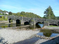
| The old bridge over the River Wnion and the A470 bypass | |||
| |||
| County | |||
| Merionethshire | |||
| Highway Authority | |||
| Gwynedd | |||
| Forward Destination on | |||
| (A458), A470, (A487), A494 | |||
| Next Primary Destinations | |||
| Bala • Betws-y-coed • Llangurig • Machynlleth • Porthmadog • Welshpool | |||
| Places related to the A470 | |||
Merthyr Tydfil • Cardiff • Conwy • Brecon • Betws-y-Coed • Builth Wells • Rhayader • Llangurig • Llandudno • Pontypridd • Blaenau Ffestiniog | |||
| Places related to the A487 | |||
| Places related to the A458 | |||
Dolgellau is a town in mid Wales and an important focus of the road network in Merionethshire and adjoining areas. It is the county town of the traditional county Merionethshire and a Primary Destination for several major roads. The A470 passes through the town – since 1981 on a new alignment, on the north bank of the River Wnion, which avoids the town centre.
Before the bypass, the major bottleneck in the town was Y Bont Fawr ("The Large Bridge") which crossed the Wnion, where traffic from both sides of the river met, along with nearby traffic coming from both sides of the Mawddach Estuary via the nearby Llanelltyd Bridge. The closing of the Great Western Railway from Ruabon to Barmouth in the late 1960s allowed the bypass to go ahead, as it was the only way a new road could avoid the town centre, due to the imposing geography on both sides. Work started in 1976, and it opened to traffic in 1981, bypassing both the town and Llanelltyd. At the same time, the A493 coast road to Tywyn was rerouted onto a new bridge over the Wnion. The A494 was rerouted to meet the bypass, and the junction later converted into a roundabout.
Because the bypass runs right alongside the river, and the whole area in general is the meeting point of several rivers into the Mawddach Estuary, a drainage pump system exists to avoid flooding.
On older maps, the name of the town is shown in the anglicized form Dolgelley, but since the town council adopted the Welsh name as standard in 1958, this use is almost extinct.
Routes
| Route | To | Notes |
| Betws-y-coed | ||
| Llangurig | ||
| Bala | ||
| Machynlleth | via A470 | |
| Porthmadog | via A470 | |
| Trallwng / Welshpool | via A470 | |
| Tywyn | ||
| Abermaw / Barmouth |


