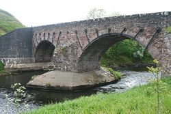
Kinbuck Bridge
Jump to navigation
Jump to search
| Kinbuck Bridge | |||
| Location Map ( geo) | |||
 | |||
| |||
| From: | Kinbuck | ||
| To: | Braco | ||
| Location | |||
| Kinbuck | |||
| County | |||
| Perthshire | |||
| Highway Authority | |||
| Stirling | |||
| Opening Date | |||
| 1752 | |||
| Additional Information | |||
| |||
| On road(s) | |||
| B8033 | |||
| Crossings related to the B8033 | |||
Kinbuck Bridge carries the B8033 across the Allan Water to the north of Dunblane. It is a narrow 2 arch structure dated 1752, which is now subject to a 10 tonne weight limit. This is despite both arches being strapped with iron bands and the cutwaters and abutments having been reinforced with a large volume of concrete.
The southern abutments have also been strengthened with newer flanking stonework in the past, with the road making a sharp turn at the southern end to avoid the hill. This hill also means that the roadway sits higher over the southern arch, descending across the bridge to a a lower level on the north side of the river.
| Kinbuck Bridge | ||||||||
| ||||||||
|


