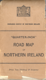
OSNI Road Map
| Road Map of Northern Ireland | |||
 | |||
| |||
| Publisher: | Ordnance Survey of Northern Ireland | ||
| Scale: | 1:253,440 | ||
| First Published: | 1926 | ||
| SABRE Maps layer: | Yes | ||
The Road Map of Northern Ireland (or Northern Ireland Road Map) series were official maps showing classified roads.
They were the Northern Ireland equivalents of the MoT Maps and the Ten-Mile Road Maps as published in Great Britain, but at a consistent Quarter-Inch scale which meant that Northern Ireland could be covered in a single sheet. They displayed as many road numbers as possible, but did not feature expanded coverage of the main urban areas. The first maps were published in 1926, meaning that the original NI numbering scheme as published in December 1923 do not have a mapping series associated with it.
Technically, Northern Ireland Road Map refers to the earlier mapping up to and including the 1935 edition; whilst Road Map of Northern Ireland is the later series from 1939 onwards. Whilst the two series follow extremely similar formats, the sheetlines of the two versions are different, with the later editions including more of County Donegal. The 1939 edition is also the location of the earliest known mapping that shows the original T and L numbering within the section of the Republic of Ireland shown on the edges of the map.
They were replaced starting in 1957 by the OSNI Quarter Inch map.
SABRE Maps coverage
SABRE Maps has full coverage of a number of NI Road Maps.
| OSNI Road Map | ||||||||
| ||||||||
|
