OS Outdoor Leisure
| Outdoor Leisure | |||
 | |||
| |||
| Publisher: | Ordnance Survey | ||
| Scale: | 1:25,000 | ||
| First Published: | 1972 | ||
| Final Publication: | 2001 | ||
| SABRE Maps layer: | No | ||
Outdoor Leisure maps are the oldest of the current 1:25,000 Ordnance Survey maps, and were created to cover National Parks and other areas popular with walkers and cyclists, as well as tourists. Over the years a total of 45 sheets appear to have been printed, although many of the earlier sheets were either short lived, or replaced with newly numbered sheets covering a more appropriate area.
The first Outdoor Leisure sheet was produced in 1972 produced from 1:25,000 First Series mapping, though by 1974 sheets were being produced from 1:25,000 Second Series data.
They were integrated into the Explorer range of mapping in 2002, althouth the ex-Outdoor Leisure sheets have kept their old sheet numbers within the Explorer range albeit with an "OL" prefix. In 2015, a number of Scottish Explorers, essentially those covering the National Parks and surrounding areas, were renumbered as OL46 - OL62, leaving gaps in the Explorer numbering.
SABRE Maps
No Outdoor Leisure coverage is available on SABRE Maps, as all sheets are still within copyright, with the first sheet going out-of-copyright in 2022. All sheets are based on underlying 1:25,000 mapping so any future coverage will probably be combined with Pathfinder mapping.
Sheets
See main article: Outdoor Leisure Sheet List
Covers
The original 1970s-issue Outdoor Leisure maps were produced in a dark mustard colour with an illustation of a bird. Later sheets based on 1:25,000 Second Series mapping were given a yellow cover, and the illustated covers were replaced by a photographic cover starting in 1984.
- OS Outdoor Leisure covers
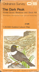
Initial style cover from 1:25,000 First Series data
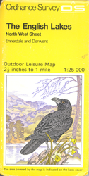
early 1980s style cover
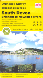
1990s style cover


| OS Outdoor Leisure | ||||||||
| ||||||||
| ||||||||
|