Westbrook Way
| Westbrook Way | |||
| Location Map ( geo) | |||
 | |||
| |||
| From: | Kingswood (SJ580905) | ||
| To: | Callands (SJ610906) | ||
| Distance: | 0.8 miles (1.3 km) | ||
| Meets: | A5281, A574 | ||
| Highway Authorities | |||
| Traditional Counties | |||
Westbrook Way is the main through-road in Westbrook – a suburb of Warrington. It has tertiary classification1 and links the A5281 from the large Whittle Avenue Roundabout (soon to link a new area) to the A574 (Cromwell Avenue) at a locally noteworthy roundabout, which features a central brick structure supporting four red pedestrian bridges forming an X-shape.
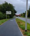
Additionally, the road's central roundabout (connecting Westbrook Crescent either side) features a high, arching red pedestrian bridge from its North-West corner to its South-East corner, seemingly intended to connect Kingswood to Westbrook Centre. The road has had dedicated cycle routes on its South side from its construction, however new developments have lead to another pedestrian and cycle path on the North of the East section; here, pavements appear to make up half of the width of the road either side.
Originally it ran at the National Speed Limit, however it has been downgraded in recent years, along with the A5281, to 40mph.
The route appears to be a remnant of an expressway in Warrington New Town's plans.2 The wide green corridor it inhabits is (and was more than) enough space to squeeze a dual carriageway. The green corridor continues straight, beyond the roundabout with the A574, as an arm of the large Sankey Valley Park, and has room to carry on even beyond the park, South of the Dallam council estate area.
Considering the nature of the road, it is surprising that it wasn't seen as the worthy recipient of the A5282 route number, in preference to a mishmash of Charon Way, Europa Boulevard and Westbrook Crescent, (Westbrook Way's actual subordinate,) all running at 30mph.
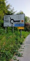
Signage at the Western end routes South-West to Liverpool (A57) and Widnes (A562), and North to Motorways (M62, M6) (towards Burtonwood Roundabout). Signage at the Eastern end routes North to (M62), (M6), Wigan (A49) and A574, and South to Warrington, (A57), A574.
References
- Freedom of Information request to Warrington Borough Council
- Warrington New Town: The bigger picture
| Westbrook Way | ||||
| ||||
|


