A770
| A770 | ||||
| Location Map ( geo) | ||||
 | ||||
| Albert Road, Gourock | ||||
| ||||
| From: | Greenock (NS279762) | |||
| To: | Inverkip (NS214732) | |||
| Distance: | 8 miles (12.9 km) | |||
| Meets: | A8, A78, A771 | |||
| Former Number(s): | A8, A78 | |||
| Primary Destinations | ||||
| Highway Authorities | ||||
| Traditional Counties | ||||
| Route outline (key) | ||||
| ||||
The A770 is the former A8 and A78 around the coast from Greenock to Inverkip. The A78 now takes the direct route to Inverkip through the Spango Valley, formerly the A742. The renumbering happened some time around 1985 when IBM greatly expanded their factory (which opened in 1951). Some people feel that the two routes should simply have swapped numbers, making this road the A742.
Route
Greenock

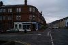
The A770 starts at the Bullring Roundabout junction with the A8 and A78. From this point, the Firth of Clyde forms the border to Zone 8. It heads north west on the wide Dalrymple Street, passing between a supermarket on the right with the Oak Mall shopping centre directly opposite. The town centre area, with traditional shopping streets to the left and retail park units to the right ends at the signalised crossroads at Patrick Street, where the main entrance to Greenock Ocean Terminal is located. Continuing north west along Brougham Street, Stacks of containers can be seen on the right before the route passes under the disused Princes Pier railway bridge. This line latterly enabled a container train service to Grenock Ocean Termional, but this ceased in the early 1980s when shipping container dimensions were increased and became too big to pass through the many tunnels on the 2.5 mile branch through Greenock from the Wemyss Bay line.
Another signalised crossroads junction offers the scenic route along The Esplanade to the right, or the residential West End to the left. Brougham Street continues to Margaret Street, at which point it becomes the ever more suburban Eldon Street. After a time high walls on the right side conceal the large rear gardens of the large houses on The Esplanade, while on the left side houses of various shapes and sizes can be seen all the way to the Gourock boundary. Many of these houses sit a little above the road so as to get views across the rooftops to the Clyde beyond. At the End of The Esplanade at Fort Matilda, the Navy Buildings and Coastguard Station have been demolished and replaced by riverside apartment blocks. Next on the right, the former WWI Royal Navy Torpedo Factory is now an industrial estate, home to a confectionary factory amongst others. The remainder of the right side of Eldon Street is taken up by the Battery Park, which runs all the way to the Gourock boundary.
Gourock


After crossing into Gourock, the sea can be seen for the first time at Cardwell Bay (an offshoot of Gourock Bay), which at high tide has been known to encroach on the A770. This coastal section is short, however, and soon houses spread out on the seaward side of the road once more. Further along Cardwell Road there is a right turn for the short A771 leading to the Gourock to Dunoon Ferry, which is a direct ferry route across the Clyde, though this is now a foot-passenger service only. At the end of the straight Cardwell Road, the A770 does a tight right after a railway bridge at the pseudo roundabout of Larkfield Junction with the C62 and C63. It then briefly runs along Chapel Street, then Shore Street, both of which run parallel to the railway and the A771 as they pass above Gourock Railway Station, terminus of the Inverclyde Line, electrified in 1967. There should be more sea views here, but a row of large mature trees blocks the view.
Shore Street continues north west, with shops and businesses in older buildings on the left, facing onto modern flats, many of which enjoy sea views. After a slight bump, the Clyde suddenly comes in to view ahead, with the Argyll and Dunbartonshire hills beyond. The route here was substantially modified in 2015 when a new one-way system was installed. The old route along Kempock Street is now for westbound traffic, while eastbound traffic was diverted onto Lower Kempock Street, a new road which was built on the seafront car park and also on a short stretch of land reclaimed from the Clyde. This greatly reduced congestion on Kempock Street, Gourock's main shopping street, and also provided a safe route for cyclists on NCN Route 75. The one way system rejoins in front of the (seasonal) heated outdoor swimming pool, with the towns war memorial stood on the forecourt.
Apart from a short terrace of houses and the yacht club on the seaward side of the road, the road runs along the coast with fine views out to Loch Long, the Holy Loch, Dunoon and the hills behind them. The road itself is at times narrow and constrained between the shoreside promenade and gardens and the properties on the landward side, each built to get maximum advantage of the views. As the houses start to thin out, the route reaches Mclnroy's Point for the second of the Dunoon Ferries, now the only vehicle service: this one crosses to Hunters Quay in northern Dunoon several times per hour at peak times. Even with such a frequent peak hour service, traffic can backup onto the A770, especially at weekends and bank holidays. A little further along on the left stands the former Castle Levan Hotel which is now in residential use and surrounded by apartment blocks. Further on, also on the left, we pass a row of new (2014-15) apartment blocks on the site of the former Ramada Jarvis Gantock Hotel at the Gourock boundary.
Cloch Road

Just outside Gourock, a junction on the left leads up a steep hill to Faulds Park industrial estate. Built at the peak of the Silicon Glen electronics boom in the 1990s, it is now home to one of Scotland's two Amazon fulfilment centres. Slighty further along on the left, another junction and another steep hill lead to the Cloch Holiday Camp which is often busy. The A770 itself stays on the shore, where the scenery remains spectacular as the coast curves southwards, opening up vistas down the Clyde towards the Isle of Bute. The prominent, and famous, Cloch Lighthouse at Cloch Point stands on the shoreside, with a long layby in front to allow people to pause and really enjoy the views. As with most of the route from Gourock, the pavement here (northbound side only, there is no path on the southbound side) has been widened and improved and is now part of NCN Route 75. It is very popular with walkers and cyclists at all times of year.

Beyond the lighthouse, the road runs along a narrow ledge between the Clyde and the steeply wooded hillside which rises up above. It snakes along the coast to Lunderston Bay where the ledge widens out at the head of a small beach, providing room for a sizeable car park and ranger station, with a busy garden centre opposite. The junction was improved in 2019-20, with central islands, crossing points and bus bays added. Shortly after leaving the bay, the road passes low red sandstone sea cliffs which come very close to the road on the left and which have small caves and seasonal waterfalls. The shore side of the road at this point is sheep and cattle pasture, with a handful of roadside trees interrupting the views. The road then twists and climbs through mature deciduous woodland at Ardgowan Estate before quickly dropping down again to join the A78 at Bankfoot Roundabout at what is known locally as 'Cloch Road End'.
The junction here used to be a simple T junction but in late 2003 / early 2004 it was rebuilt as a roundabout. Turning left here takes traffic northeastward back to Greenock by the direct route; right leads south to Wemyss Bay (ferry to Bute) and Largs (Vikingar! leisure centre and ferry to Great Cumbrae).
History
Before its re-routing in 1985, this route had two numbers. It was split between the A8 (east of Kempock Point) and the A78 to the west. This appears to be the split shown on the 1923 MOT map (left), although when the A78 was re-routed in 1985 the A8 was truncated allowing the A770 to take over part of both routes. Interestingly, although subsequent A7xx numbers had been used earlier, this is the first known use of the A770 number. Being a largely urban route, apart from the recent new one way system in Gourock and the junction improvements at Lunderston Bay, there have been very few changes to the route since it was renumbered in 1985, and perhaps not since 1922 when the roads were first classified.